
 United Kingdom
 France
 Germany
 Netherlands
 Sweden
 USA
USA
 Italy
Italy
 Spain
Spain
More From Contributor

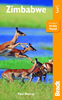


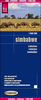
Zimbabwe Map Studio Adventure Map
Zimbabwe at 1:1, 200, 000 on an indexed road map from Map Studio, with good presentation of the country’s topography, GPS waypoints for important road junctions, locations of filling stations, plus a large street plan of central Harare, The main map presents the network of roads and tracks, marking locations of borders crossings and petrol stations, and giving driving distances on main routes. Numerous GPS waypoints are provided for larger settlements or important road junctions. The map also shows the railway lines, local airfields, and internal administrative boundaries with names of the provinces. Symbols indicate locations with different types of tourist accommodation including campsites, medical facilities, and various points of interest. Topography is presented by
altitude colouring and national parks/safari areas are highlighted. In addition of GPS waypoints, latitude and longitude lines are drawn at 1ºn intervals. The index is next to the map.A large inset shows central Harare highlighting main traffic routes and selected places of interest including embassies, etc.
altitude colouring and national parks/safari areas are highlighted. In addition of GPS waypoints, latitude and longitude lines are drawn at 1ºn intervals. The index is next to the map.A large inset shows central Harare highlighting main traffic routes and selected places of interest including embassies, etc.
Product Description
Reviews/Comments
Add New
Vouchers
No voucher codes found.
Do you know a voucher code for this product or supplier? Add it to Insights for others to use.
Do you know a voucher code for this product or supplier? Add it to Insights for others to use.
 Denmark