
 United Kingdom
 France
 Germany
 Netherlands
 Sweden
 USA
USA
 Italy
Italy
 Spain
Spain
More From Contributor


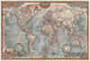


World Executive Ray & Co Wall Map PAPER
The World Executive Map from Ray & Co. (136 x 92 cm / 3’5” x 3” approx.) presents a political map of the world in a style and colouring reminiscent of the old antique maps, with countries defined by different colour borders.Country, city and other place names are given in English. Plenty of names of geographical features are provided to supplement the lovely drawings of mountain chains. Insets present Antarctica and the Polar regions. On oceans sea floor ridges are shown and directions of currents and trade winds are marked.The Equator and the Greenwich Meridian are indicated by colourful lines, with other latitude and longitude lines drawn at 15° intervals and presented with clocks indicating approximate time zones. A rosette gives the points of the compass and map corners are
decorated with panels of flags. * This map is also available encapsulated.
decorated with panels of flags. * This map is also available encapsulated.

Product Description
Reviews/Comments
Add New
Vouchers
No voucher codes found.
Do you know a voucher code for this product or supplier? Add it to Insights for others to use.
Do you know a voucher code for this product or supplier? Add it to Insights for others to use.
 Denmark