
 United Kingdom
 France
 Germany
 Netherlands
 Sweden
 USA
USA
 Italy
Italy
 Spain
Spain
More From Contributor


World Eckert IV Projection OS Wall Map LAMINATED
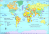
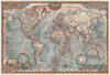
Political map of the world from the Ordnance Survey, size 123.5 x 91.5 cm / 48” x 36” approx, ideal for schools, with an Eckert IV equal area projection and a panel explaining how it works, flags and country facts, laminated surface suitable for marking, etc.The main map presents the world on an equal area projection so that all the countries are shown in the correct proportion to their true area. Political colouring by country is supplemented by relief shading to show mountain ranges and names of main physical features are included. All place names are in their English versions. Latitude and longitude lines are drawn at 15° intervals.Four insets present the northern and southern hemispheres with colouring by continents and climate/vegetation; another inset presents the world
Pacific-centred. Country flags are accompanied by details of area and population. The map also includes notes and illustrations explaining how projections and show either equal areas or correct shapes of the continents.LAMINATED and ENCAPSULATED WALL MAPS:- LAMINATED wall maps have a thin layer of plastic usually applied to the printed side only. They can be written on with suitable marker pens without any damage to the map but, unless laminated on both sides, they are not damp-proof.- ENCAPSULATED wall maps are sealed between two sheets of plastic. They are more rigid and heavier than laminated maps of the same size. They are damp-proof and do not crinkle in humid conditions. Encapsulation gives the map a shiny surface, similar to being displayed behind glass.- PLEASE NOTE: many
publishers and retailers often use these two terms interchangeably. Our map titles and descriptions follow the definitions provided above.

Product Description
Reviews/Comments
Add New
Vouchers
No voucher codes found.
Do you know a voucher code for this product or supplier? Add it to Insights for others to use.
Do you know a voucher code for this product or supplier? Add it to Insights for others to use.
 Denmark