More From Contributor

£10.99
The world upside down as seen from the Down Under: a map of the world from the Australian publishers UBD Gregory’s showing on one side a political version & on the reverse a physical map. Both maps are Pacific centred, so Australia & New Zealand are on top & in the centre. On one side is a political map of the world in nice pastel colours. On the reverse, the less often seen & much more interesting physical version of the “upside down” presentation provides even greater contrast to the usual view of the world with the north on top. ...
Archived Product
£9.99
Political map of the world from the Ordnance Survey, size 123.5 x 91.5 cm / 48” x 36” approx, ideal for schools, with an Eckert IV equal area projection & a panel explaining how it works, flags & country facts, laminated surface suitable for marking, etc. The main map presents the world on an equal area projection so that all the countries are shown in the correct proportion to their true area. Political colouring by country is supplemented by relief shading to show mountain ranges & names of main physical features are included. All place names are in their English versions. Latitude & longitude lines are drawn at 15° intervals. Four insets present the northern & southern hemispheres with colouring by continents & climate/vegetation; another inset presents the world Pacific-centred. Country flags are accompanied by details of area & population. The map also

Includes::
notes & illustrations explaining how projections & show either equal areas or correct shapes of the continents.LAMINATED & ENCAPSULATED WALL MAPS:- LAMINATED wall maps have a thin layer of plastic usually applied to the printed side only. They can be written on with suitable marker pens without any damage to the map but, unless laminated on both sides, they are not damp-proof.- ENCAPSULATED wall maps are sealed between two sheets of plastic. They are more rigid & heavier than laminated maps of the same size. They are damp-proof & do not crinkle in humid conditions. Encapsulation gives the map a shiny surface, similar to being displayed behind glass.- PLEASE NOTE: many publishers & retailers often use these two terms interchangeably. Our map titles & descriptions follow the definitions provided above.

...
Archived Product
£7.95
World Educational Map Set from ITMB consists of two separate, laminated political maps of the world, both slightly larger than A4

Size:
one with place names of countries, major cities & important geographical features such mountain peaks, rivers & lakes, the other just an outline map for names to be filled in. Both maps have laminated, write-on-wipe-off surface & are waterproof. A simple but a very effective way to learn quickly what’s where!PLEASE NOTE: although the set is very light, the measurements exceed the size allowed for letter post, hence the slightly higher postage charge.

...
Archived Product
£4.99
The Atlas of True Names reveals the etymological roots, or original meanings, of the familiar terms on today`s map of the World. For instance, where you would normally expect to see the Sahara indicated, the ‘ Atlas’ gives you ” Sea of Sand”, Arab. es-sahra ”desert, sea of sand”. The ` True Names` of 1500 cities, countries, rivers, oceans & mountain ranges are displayed on this fascinating map, which

Includes::
a comprehensive index of derivations. Etymology is the study of the origin & history of words. For the first time, the ‘ Atlas of True Names’ uses etymology to give us an unusual insight into familiar geographical names
- with intriguing results...... Many geographical names are clearly rooted in Man’s observation of his natural environment; the physical location of a settlement: “ At the Foot of the Mountain”
- Piedmont, the character of an important water course: “ The Gentle One”
- The Seine or even just the local vegetation: “ Under the Oaks”
- Potsdam. Unsurprisingly, countries & landscapes often derive their names from the characteristics of the people who lived there: “ Great Land of the Tattooed”
- Great Britain, whilst local mythology & regional rulers also frequently leave their legacy: “ Isle of the Monster’s Eye”
- Peleponnese or “ Illustrious Emperor”
- Zaragoza. The ‘ Atlas of True Names’ restores an element of enchantment to the world we all think we know so well. It takes the reader on a journey into the unknown
- a unique exploration of uncharted territory in that familiar place we all know as ‘home’. Take a look at the world through fresh eyes!


...
Archived Product
£14.99
Etymological Wall Map of the World, called by its publishers Kalimedia
- the Atlas of True Names (size 100 x 70cm / 39.5” x 27.5”
...
Archived Product
£19.99
The World Executive Map from Ray & Co. (136 x 92 cm / 3’5” x 3” approx.) presents a political map of the world in a style & colouring reminiscent of the old antique maps, with countries defined by different colour borders. Country, city & other place names are given in English. Plenty of names of geographical features are provided to supplement the lovely drawings of mountain chains. Insets present Antarctica & the Polar regions. On oceans sea floor ridges are shown & directions of currents & trade winds are marked. The Equator & the Greenwich Meridian are indicated by colourful lines, with other latitude & longitude lines drawn at 15° intervals & presented with clocks indicating approximate time zones. A rosette gives the points of the compass & map corners are decorated with panels of flags. * This map is also available encapsulated. ...
Archived Product
£19.99
Large size, 176x 122.5cm (69”x 48” approx), political wall map of the world from Freytag & Berndt in an international edition with all place names in their English versions, presenting countries in pleasant pastel colours against light blues seas. On landmasses the map shows main road & rail connections; in USA, Canada, Brazil & Australia also shown are names & boundaries of states/provinces. Physical relief is indicated by names of mountain ranges, peaks, deserts, etc. Polar Regions are presented on insets, showing limits of drift ice & the ice shelf. Latitude & longitude lines are drawn at 10º intervals. Boxes along the sides & the bottom of the map shows each country’s flag, capital city, area & population. Map legend

Includes::
English.PLEASE NOTE: this wall map is also available in a smaller 122x 86cm version. To see the other versions please click on the series link.

...
Archived Product
£13.99
Medium size, 122x 86cm (48”x 32” approx), political wall map of the world from Freytag & Berndt in an international edition with all place names in their English versions, presenting countries in pleasant pastel colours against light blues seas. On landmasses the map shows main road & rail connections; in USA, Canada, Brazil & Australia also shown are names & boundaries of states/provinces. Physical relief is indicated by names of mountain ranges, peaks, deserts, etc. Polar Regions are presented on insets, showing limits of drift ice & the ice shelf. Latitude & longitude lines are drawn at 10º intervals. Boxes along the sides & the bottom of the map shows each country’s flag, capital city, area & population. Map legend

Includes::
English.PLEASE NOTE: this medium size is also available with metal hanging strips, & the same presentation is also published in a larger 176x 122.5cm size. To see the other versions please click on the series link.

...
Archived Product
£8.99
Flags are a great way to show some national pride, pay homage to a fondly remembered visit abroad, celebrate a special occasion, or simply decorate the wall of your room. Stanfords offer flags for most countries of the world, & some special non-country flags too. These flags measure 152 x 92cm (5` x 3`), are made from 100% polyester & come with two brass eyelets for fastening. Stanfords also stock some [LINK:1977caption:smaller flags], measuring 92 x 61cm (3` x 2`) ...
Archived Product
£5.99
Fully updated for 2005, this wall chart features a brightly coloured political map of the World, with clear lettering & symbols for easy reference. Countries are picked out in distinctive colours to aid identification, with town & city names clearly shown. Major administrative areas (states & provinces) are marked in the largest countries: Canada, United States, Brazil, Russia, China & Australia. The scale at the equator is 1:47 600 000. Also included on the chart are 188 flags of the countries of the world, arranged in alphabetical order from Afghanistan to Zimbabwe, & fully updated for this edition. This wall chart is supplied in two versions: (a) laminated on one side & rolled into a clear plastic tube for use as a wall map; and (b) unlaminated & folded with a tipped-on card cover for use when travelling. It is ideal for mounting on a bedroom wall or in the classroom or office
- the clarity of the name detail ensures that it is useful for both adults & children. Main map scale:
...
Archived Product

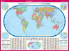
World Executive Ray & Co Wall Map ENCAPSULATED

Encapsulated version of The World Executive Map from Ray & Co. (136 x 92 cm / 3’5” x 3” approx.) which presents a political map of the world in a style and colouring reminiscent of the old antique maps, with countries defined by different colour borders.Country, city and other place names are given in English. Plenty of names of geographical features are provided to supplement the lovely drawings of mountain chains. Insets present Antarctica and the Polar regions. On oceans sea floor ridges are shown and directions of currents and trade winds are marked.The Equator and the Greenwich Meridian are indicated by colourful lines, with other latitude and longitude lines drawn at 15° intervals and presented with clocks indicating approximate time zones. A rosette gives the points of the
compass and map corners are decorated with panels of flags.* This map is also available on paper.*LAMINATED and ENCAPSULATED WALL MAPS:**laminated* wall maps have a thin layer of plastic usually applied to the printed side only. They can be written on with suitable marker pens without any damage to the map but, unless laminated on both sides, they are not damp-proof.*encapsulated* wall maps are sealed between two sheets of plastic. They are more rigid and heavier than laminated maps of the same size. They are damp-proof and do not crinkle in humid conditions. Encapsulation gives the map a shiny surface, similar to being displayed behind glass.*please note:* many publishers and retailers often use these two terms interchangeably. Our map titles and descriptions follow the definitions
provided above.
RIP - This product is no longer available on our network. It was last seen on 25.09.2019

This page now acts as a permanent archive for this product. Add more information using the comments box below to ensure it can still be found by future generations.

Use our search facility to see if it is available from an alternative contributor.
  • Availability: Out Of Stock
  • Supplier: Stanfords
  • SKU: 9789539578341
Availability: In Stock
£29.99

Product Description

Encapsulated version of The World Executive Map from Ray & Co. (136 x 92 cm / 3’5” x 3” approx.) which presents a political map of the world in a style & colouring reminiscent of the old antique maps, with countries defined by different colour borders. Country, city & other place names are given in English. Plenty of names of geographical features are provided to supplement the lovely drawings of mountain chains. Insets present Antarctica & the Polar regions. On oceans sea floor ridges are shown & directions of currents & trade winds are marked. The Equator & the Greenwich Meridian are indicated by colourful lines, with other latitude & longitude lines drawn at 15° intervals & presented with clocks indicating approximate time zones. A rosette gives the points of the compass & map corners are decorated with panels of flags.* This map is also available on paper.*LAMINATED & ENCAPSULATED WALL MAPS:**laminated* wall maps have a thin layer of plastic usually applied to the printed side only. They can be written on with suitable marker pens without any damage to the map but, unless laminated on both sides, they are not damp-proof.*encapsulated* wall maps are sealed between two sheets of plastic. They are more rigid & heavier than laminated maps of the same size. They are damp-proof & do not crinkle in humid conditions. Encapsulation gives the map a shiny surface, similar to being displayed behind glass.*please note:* many publishers & retailers often use these two terms interchangeably. Our map titles & descriptions follow the definitions provided above.

Reviews/Comments

Add New

Intelligent Comparison

Oooops!
We couldn't find anything!
Perhaps this product's unique.... Or perhaps we are still looking for comparisons!
Click to bump this page and we'll hurry up.

Price History

Vouchers

No voucher codes found.
Do you know a voucher code for this product or supplier? Add it to Insights for others to use.

Facebook

Jargon Buster

Paper - A thin sheet mainly used for writing. Available in a variety of colours. Made mainly from wood pulp.
Plastic - A generic term for a synthetic product used in the manufacture of products
Cm - Centimetres, one centimetre is equal to 10 milimetres
Glass - A solid, typically transparent. Brittle and used in windows. The first patent granted in the UK was for Glass.
antique - An old collectible item with desirable qualities.
Wall - A physical barrier between two areas
World - A physical grouping, commonly used to describe earth and everything associated with ti
Colour - The categorised spectrum of light visable to humans
Size - is the measurement of how big an object is in space.
Greenwich - A southern borough in London.
Layer - Adding extra quantities of materials for extra practical benefits, e.g. warmth.
Laminated - A thin layer of plastic that gives a coating and shine to a material.
Borders - A line that sometimes can be built up separating off an area, e.g. countries "the welsh boarder"
Shiny - A smooth reflective surface, e.g. a metal spoon.
Humid - When water vapour is high in the atmosphere making it feel stuffy.

Supplier Information

Stanfords
Stanfords was established in 1853 and opened their iconic Covent Garden flagship store in 1901. They have become the top retailer of maps, travel books and accessories in the UK and arguably offer the largest selection of maps and travel books worldwide. Famous names such as Captain Robert Falcon Scott, Ranulph Fiennes and Michael Palin have purchased from Stanfords. They now have a shop in Bristol and both stores together with other venues operate a calendar of events including talks, book signings and exhibitions. As a specialist map retailer, the map selection is comprehensive and includes road maps, street maps and walking maps from worldwide destinations, as well as a selection of world atlases and wall maps. Books include travel guides and travel literature. Stanfords also stock globes, from miniatures made of blue marble to magnificent floor-standing globes. The website features a selection of interesting articles on travel topics.
Page Updated: 2023-11-12 20:15:36

Community Generated Product Tags

Oh No! The productWIKI community hasn't generated any tags for this product yet!
Menu