
 United Kingdom
 France
 Germany
 Netherlands
 Sweden
 USA
USA
 Italy
Italy
 Spain
Spain
More From Contributor


World Flags (folded)
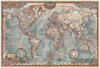
Fully updated for 2005, this wall chart features a brightly coloured political map of the World, with clear lettering and symbols for easy reference. Countries are picked out in distinctive colours to aid identification, with town and city names clearly shown. Major administrative areas (states and provinces) are marked in the largest countries: Canada, United States, Brazil, Russia, China and Australia. The scale at the equator is 1:47 600 000.Also included on the chart are 188 flags of the countries of the world, arranged in alphabetical order from Afghanistan to Zimbabwe, and fully updated for this edition.This wall chart is supplied in two versions:(a) laminated on one side and rolled into a clear plastic tube for use as a wall map; and(b) unlaminated and folded with a
tipped-on card cover for use when travelling.It is ideal for mounting on a bedroom wall or in the classroom or office - the clarity of the name detail ensures that it is useful for both adults and children.Main map scale:
tipped-on card cover for use when travelling.It is ideal for mounting on a bedroom wall or in the classroom or office - the clarity of the name detail ensures that it is useful for both adults and children.Main map scale:
 "Pin It")
Product Description
Reviews/Comments
Add New
Vouchers
No voucher codes found.
Do you know a voucher code for this product or supplier? Add it to Insights for others to use.
Do you know a voucher code for this product or supplier? Add it to Insights for others to use.
 Denmark