
 United Kingdom
 France
 Germany
 Netherlands
 Sweden
 USA
USA
 Italy
Italy
 Spain
Spain
More From Contributor


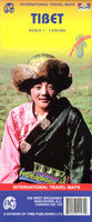
Tibet
Large double-sided map of Tibet with insets of the Lhasa Valley, the Norbulingka, the Potala area and the Barkor area. Elevation tinting in pastel shades shows the general relief, with selected mountain peak altitudes marked. International, disputed, and provincial/regional borders are all clearly marked, as are railways. Main roads are marked with their distances; connecting roads, tracks and

Product Description
Reviews/Comments
Add New
Intelligent Comparison
Archived Product
Tibet Stanfords
£9.50
Archived Product

Tibet Stanfords
£13.59
Archived Product
Tibet Stanfords
£9.50
Archived Product
Tibet Stanfords
£13.99
Archived Product
Tibet Stanfords
£17.99
Archived Product
Tibet Stanfords
£10.50
Archived Product

Tribe Stanfords
£8.99
Archived Product
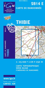
Thibie Stanfords
£11.50
Vouchers
No voucher codes found.
Do you know a voucher code for this product or supplier? Add it to Insights for others to use.
Do you know a voucher code for this product or supplier? Add it to Insights for others to use.
 Denmark