
 United Kingdom
 France
 Germany
 Netherlands
 Sweden
 USA
USA
 Italy
Italy
 Spain
Spain
More From Contributor


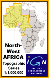
Tibesti Est IGN NF-34
One of the titles in a series of topographic maps covering much of north-west Africa, produced as part of the IMW* project in 1960’s. Each map covers an area spanning 6° in longitude and 4° in latitude. There is some variation in colouring and the depiction of terrain, but hill-shading, spot heights and contours are used to show the general relief. Additional graphics show features such as dunes, rock outcrops, cliffs, sand areas, escarpments, marshes, seasonal lakes and watercourses, and areas liable to flooding. Bathymetric contours are also included.Communications detail includes roads, major trails and railways, although there is some inconsistency in colouring and the extent of classification, e.g. not all maps distinguish seasonal roads. On most maps intermediate
road distances are indicated on main routes. Symbols show airports, mosques, mines, oil and gas fields, lighthouses, ruins and significant isolated buildings. Administrative boundaries are marked and latitude and longitude lines are drawn at 1° intervals, with further margin ticks at 1’ intervals. The map legend is in French only on some sheets, and in English and French on others.*The International Map of the World was a project conceived in the early 20th century to compile a world map series at 1:1, 000, 000 through the efforts of participating nations. The value of the program has declined since 1970 and the IMW is no longer regarded as an active international series.
road distances are indicated on main routes. Symbols show airports, mosques, mines, oil and gas fields, lighthouses, ruins and significant isolated buildings. Administrative boundaries are marked and latitude and longitude lines are drawn at 1° intervals, with further margin ticks at 1’ intervals. The map legend is in French only on some sheets, and in English and French on others.*The International Map of the World was a project conceived in the early 20th century to compile a world map series at 1:1, 000, 000 through the efforts of participating nations. The value of the program has declined since 1970 and the IMW is no longer regarded as an active international series.

Product Description
Reviews/Comments
Add New
Vouchers
No voucher codes found.
Do you know a voucher code for this product or supplier? Add it to Insights for others to use.
Do you know a voucher code for this product or supplier? Add it to Insights for others to use.
 Denmark