
 United Kingdom
 France
 Germany
 Netherlands
 Sweden
 USA
USA
 Italy
Italy
 Spain
Spain
More From Contributor


Tibet
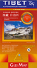
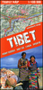
Tibet on an indexed overview map at 1:1, 500, 000 from the Kathmandu-based Nepa Maps, with coverage extending west/east from Dawa/Dapa and Montser/Moincer (west of Mt. Kailash) to Nakchu north-east of Lhasa. In the north the map extends to approx, 33º, and south of the Tibetan border coverage includes the whole of Nepal, and Bhutan, with Sikkim and the Indian Himalaya, plus parts of the adjoining Indian states.Topography is shown by shading based on the satellite imagery, with plenty of peak heights marked on the map. In Tibet the map shows the network of main and secondary road connections, the railway route to Lhasa, plus local airports. Symbols indicate locations with tourist accommodation and various places of interest are highlighted.Relief shading and tourist information
continues in Nepal, Bhutan, Sikkim and Uttaranchal, but in India south of the Nepali border only road and rail connections are shown. All place names are in the Latin alphabet, with both Tibetan and Chinese versions given for selected locations. The map has latitude and longitude margin ticks at 30’ intervals. The index is next to the map and lists places and lakes, plus (mainly in Nepal) peaks, base camps and passes.
continues in Nepal, Bhutan, Sikkim and Uttaranchal, but in India south of the Nepali border only road and rail connections are shown. All place names are in the Latin alphabet, with both Tibetan and Chinese versions given for selected locations. The map has latitude and longitude margin ticks at 30’ intervals. The index is next to the map and lists places and lakes, plus (mainly in Nepal) peaks, base camps and passes.

Product Description
Reviews/Comments
Add New
Vouchers
No voucher codes found.
Do you know a voucher code for this product or supplier? Add it to Insights for others to use.
Do you know a voucher code for this product or supplier? Add it to Insights for others to use.
 Denmark