More From Contributor
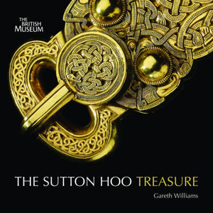
£15.99
Published by Sustrans, the creator of the National Cycle Network, this is the official guidebook which brings together 150 of the country`s finest traffic-free walking & cycling routes in celebration of twenty years of the NCN. Offering a unique glimpse into the UK`s remarkable landscapes, history, culture & architecture, the rides range from the wild & ethereal mountain tracks of Snowdonia to fairytale woodland trails through the Forest of Dean & elegant city centre paths linking London`s Royal Parks & palaces. Fully illustrated with maps & photographs, the guide

Includes::
routes for all ages & abilities, cycle-friendly places to stay & eat, bike hire centres, public transport links & things to see along the way. There is insightful advice on extending the rides or connecting to other nearby routes. Inspiring & informative this is a comprehensive guide to traffic-free cycling & a fitting 20th anniversary tribute to the Network Cycle Network. It may be complemented with Sustrans` series of pocket cycle maps where each ride has a suggested wider area map to use.

...
Archived Product
£29.99
Map No. 3220, Sutherl&, in South Africa’s official topographic survey at 1:250, 000 from the country’s national survey organization, the Chief Directorate of Surveys & Mapping. The maps have altitude colouring & contours at 50m or 100m intervals, depending on the map edition, plus spot heights. Deserts, marshes, dry pans, perennial & seasonal water features, etc, as well as protected areas are shown. The maps present the country’s road & rail networks & include the usual information expected on topographic mapping at this scale, although in more rapidly developing areas road information may not necessarily be up to date. Also indicated are magisterial district & provincial boundaries. Latitude & longitude values are shown in the margins at 5` intervals together with South African grid co-ordinates. Typically, each sheet covers an area of one degree of latitude & two degrees of longitude. The projection used is Gauss Conformal. The legend is in English & Afrikaans. ...
Archived Product
£3.50
Sutton in 1895 in a fascinating series of reproductions of old Ordnance Survey plans in the Alan Godfrey Editions, ideal for anyone interested in the history of their neighbourhood or family. The map covers the centre & southern area of Sutton, stretching from West Street southward along the High Street & then Brighton Road to Egmont Road & Sutton Farm. Coverage also extends westward to Lower Cheam, the Manor House & Cheam station. Features include Sutton station, St Nicholas parish church, Lower Cheam House (built in 1800 on the site of East Cheam Manor House), Sutton Public Hall. The boundary between Cheam & Sutton runs north-south down the map, & east of this numerous streets reflect Sutton`s growth. Street directories for Carshalton Road, Cavendish Road, Cedar Road, Cheam Road, Grange Road, Grove Road & High Street are on the reverse. About the Alan Godfrey Editions of the 25” OS Series: Selected towns in Great Britain & Ireland are covered by maps showing the extent of urban development in the last decades of the 19th & early 20th century. The plans have been taken from the Ordnance Survey mapping & reprinted at about 15 inches to one mile (1:4, 340). On the reverse most maps have historical notes & many also include extracts from contemporary directories. Most maps cover about one mile (1.6kms) north/south, one & a half miles (2.4kms) across; adjoining sheets can be combined to provide wider coverage.FOR MORE INFORMATION & A COMPLETE LIST OF ALL AVAILABLE TITLES PLEASE CLICK ON THE SERIES LINK. ...
Archived Product
£2.95
Sutton Coldfield in 1913 in a fascinating series of reproductions of old Ordnance Survey plans in the Alan Godfrey Editions, ideal for anyone interested in the history of their neighbourhood or family. Selected towns in Great Britain & Ireland are covered by maps showing the extent of urban development in the last decades of the 19th & early 20th century. In this title: the map covers most of Sutton Coldfield, a few miles north of Birmingham but distinctly a town in its own right. Coverage stretches from Park House & Clifton Road eastward to Reddicap Hill & Boot Hill & from Upper Holland Road northward to Barker Road. Features include Holy Trinity church, Town Hall, King Edward's Square, Tudor Laundry, Cottage Hospital, cemetery, Royal Hotel, Holy Trinity RC church, LNWR railway with station, Midland Railway with Sutton Town & Sutton Park stations, Crystal Palace, site of Manor, Tudor Hill, Grammar School, etc. On the reverse is the commercial entry from a 1912 directory. About the Alan Godfrey Editions of the 25 ...
Archived Product
£9.99
The Sutton Hoo site is one of the most important archaeological discoveries ever made in Britain, & arguably the world. Since the initial discovery of the ship burial in 1938, when newspaper reports with banner headlines kept the British public informed about the event, the mound burials & surrounding cemetery have yielded a wealth of archaeological evidence as well as glittering treasures. Martin Carver draws on the full range of research undertaken at the site, which was still being excavated in 1993, to present a story of the archaeological discovery. Beginning with the excavations, he goes on to tell the story of the site itself. ...
Archived Product
£2.95
Sutton North in 1910 in a fascinating series of reproductions of old Ordnance Survey plans in the Alan Godfrey Editions, ideal for anyone interested in the history of their neighbourhood or family. Selected towns in Great Britain & Ireland are covered by maps showing the extent of urban development in the last decades of the 19th & early 20th century. In this title: the map covers the north of Sutton, including Benhilton, from Clensham Lane to Manor Lane & eastward to Benhill Road. Features include St Barnabas church, Newtown area, tramway, Benfleet Hall, Benhilton area, The Green, All Saints church, Hallmead Farm, fireworks manufactory, Gandergreen Lane, etc. About the Alan Godfrey Editions of the 25 ...
Archived Product
£3.50
Sutton North in 1910 in a fascinating series of reproductions of old Ordnance Survey plans in the Alan Godfrey Editions, ideal for anyone interested in the history of their neighbourhood or family. The map covers the north of Sutton, including Benhilton, from Clensham Lane to Manor Lane & eastward to Benhill Road. Features include St Barnabas church, Newtown area, tramway, Benfleet Hall, Benhilton area, The Green, All Saints church, Hallmead Farm, fireworks manufactory, Gandergreen Lane, etc. About the Alan Godfrey Editions of the 25” OS Series: Selected towns in Great Britain & Ireland are covered by maps showing the extent of urban development in the last decades of the 19th & early 20th century. The plans have been taken from the Ordnance Survey mapping & reprinted at about 15 inches to one mile (1:4, 340). On the reverse most maps have historical notes & many also include extracts from contemporary directories. Most maps cover about one mile (1.6kms) north/south, one & a half miles (2.4kms) across; adjoining sheets can be combined to provide wider coverage.FOR MORE INFORMATION & A COMPLETE LIST OF ALL AVAILABLE TITLES PLEASE CLICK ON THE SERIES LINK. ...
Archived Product
£2.95
Sutton-in-Ashfield in 1914 in a fascinating series of reproductions of old Ordnance Survey plans in the Alan Godfrey Editions, ideal for anyone interested in the history of their neighbourhood or family. Selected towns in Great Britain & Ireland are covered by maps showing the extent of urban development in the last decades of the 19th & early 20th century. In this title: the map covers the central, northern & eastern parts of Sutton in Ashfield, with coverage stretching from Albert Square northward to Forest Road & eastward to Coxmoor Road. Features include GNR railway with station, tramways, St Mary Magdalen church, Colliery Houses, Portland Square, New Cross area, Deepdale area, Skegby Forest, quarries, Sutton Forest Side area, The Old Mill, Dalestorth Brick Works, St Michael & All Angels church, Sutton Grange etc. On the reverse is a directory of Sutton in Ashfield in 1891. About the Alan Godfrey Editions of the 25 ...
Archived Product
£3.50
Sutton-in-Ashfield in 1914 in a fascinating series of reproductions of old Ordnance Survey plans in the Alan Godfrey Editions, ideal for anyone interested in the history of their neighbourhood or family. The map covers the central, northern & eastern parts of Sutton in Ashfield, stretching from Albert Square northward to Forest Road & eastward to Coxmoor Road. Features include GNR railway with station, tramways, St Mary Magdalen church, Colliery Houses, Portland Square, New Cross area, Deepdale area, Skegby Forest, quarries, Sutton Forest Side area, The Old Mill, Dalestorth Brick Works, St Michael & All Angels church, Sutton Grange, etc. On the reverse is a directory of Sutton in Ashfield in 1891. About the Alan Godfrey Editions of the 25” OS Series: Selected towns in Great Britain & Ireland are covered by maps showing the extent of urban development in the last decades of the 19th & early 20th century. The plans have been taken from the Ordnance Survey mapping & reprinted at about 15 inches to one mile (1:4, 340). On the reverse most maps have historical notes & many also include extracts from contemporary directories. Most maps cover about one mile (1.6kms) north/south, one & a half miles (2.4kms) across; adjoining sheets can be combined to provide wider coverage.FOR MORE INFORMATION & A COMPLETE LIST OF ALL AVAILABLE TITLES PLEASE CLICK ON THE SERIES LINK. ...
Archived Product
£23.99
Karttakeskus’ Water touring maps are a completely new type of map series. The pre-folded maps made from waterproof & rip-proof material can fit into a small space on the boat, but when opened, they cover a wide area. In this way, the water touring map is e.g. an excellent planning tool alongside electronic navigation solutions, offering a wide overview for e.g. route planning. On the other h&, the waterproof material makes the map easy to handle in e.g. an open boat or sailing boat. Water touring maps: In land areas, the maps have been supplemented with the National Land Survey of Finland’s Topographic Database material. New map sheet division. Size 70 × 100 cm, folded 23.3 × 11.3 cm. Additional themes incl. slipways & camp fire sites & landfalls. Scale in maritime areas 1:60 000, inland waterways 1:50 000 Base map source: Finnish Transport Agency. Not for navigation use. Does not meet the requirements of an official nautical chart. ...
Archived Product

Sutton Hoo Treasure

The objects unearthed in 1939 from an Anglo-Saxon ship-burial at Sutton Hoo, Suffolk, rank among the most splendid treasures in the collection of the British Museum. Bringing together fine craftsmanship from England, Germany, Scandinavia, Alexandria and far Byzantium, the spectacular finds included gold and garnet jewellery, silverware, drinking vessels with silver-gilt fittings, a lyre and a sceptre, as well as the iconic helmet, all deliberately buried in the early seventh century as grave-goods for an important, though unidentified, warrior. The Sutton Hoo ship-burial was one of the most exciting discoveries ever made in British archaeology. This beautifully designed introduction to the treasure details the most significant pieces contained within it and explores the
circumstances of its burial, discovery and excavation, as well as its lasting legacy and fame.
RIP - This product is no longer available on our network. It was last seen on 25.09.2019

This page now acts as a permanent archive for this product. Add more information using the comments box below to ensure it can still be found by future generations.

Use our search facility to see if it is available from an alternative contributor.
  • Availability: Out Of Stock
  • Supplier: Stanfords
  • SKU: 9780714128252
Availability: In Stock
£4.99

Product Description

The objects unearthed in 1939 from an Anglo-Saxon ship-burial at Sutton Hoo, Suffolk, rank among the most splendid treasures in the collection of the British Museum. Bringing together fine craftsmanship from Engl&, Germany, Scandinavia, Alexandria & far Byzantium, the spectacular finds included gold & garnet jewellery, silverware, drinking vessels with silver-gilt fittings, a lyre & a sceptre, as well as the iconic helmet, all deliberately buried in the early seventh century as grave-goods for an important, though unidentified, warrior. The Sutton Hoo ship-burial was one of the most exciting discoveries ever made in British archaeology. This beautifully designed introduction to the treasure details the most significant pieces contained within it & explores the circumstances of its burial, discovery & excavation, as well as its lasting legacy & fame.

Reviews/Comments

Add New

Intelligent Comparison

Oooops!
We couldn't find anything!
Perhaps this product's unique.... Or perhaps we are still looking for comparisons!
Click to bump this page and we'll hurry up.

Price History

Vouchers

No voucher codes found.
Do you know a voucher code for this product or supplier? Add it to Insights for others to use.

Facebook

Jargon Buster

Gold - A precious highly conductive metal
Silver - A colour based on the colour of the metal
Silver - A chemical element, metalic. Has the highest elctrical conductance of any element. Also known for its exceptional anitmicrobal properties
Helmet - A form of protection worn on the head to prevent injury
Jewellery - A decorative item which is worn on the body
England - A country within the United Kingdom.
Germany - A country in Central Europe.
Gold - A colour, a type of rich metal. Chemical symbol AU.
Spectacular - Something that catches that eye due to its eye catchingness.
Museum - A building which exhibits old artefacts for viewing of people who show interest.

Supplier Information

Stanfords
Stanfords was established in 1853 and opened their iconic Covent Garden flagship store in 1901. They have become the top retailer of maps, travel books and accessories in the UK and arguably offer the largest selection of maps and travel books worldwide. Famous names such as Captain Robert Falcon Scott, Ranulph Fiennes and Michael Palin have purchased from Stanfords. They now have a shop in Bristol and both stores together with other venues operate a calendar of events including talks, book signings and exhibitions. As a specialist map retailer, the map selection is comprehensive and includes road maps, street maps and walking maps from worldwide destinations, as well as a selection of world atlases and wall maps. Books include travel guides and travel literature. Stanfords also stock globes, from miniatures made of blue marble to magnificent floor-standing globes. The website features a selection of interesting articles on travel topics.
Page Updated: 2023-11-12 20:15:36

Community Generated Product Tags

Oh No! The productWIKI community hasn't generated any tags for this product yet!
Menu