More From Contributor

£12.99
Sustenpass, map No. 255, in the standard topographic survey of Switzerland at 1:50, 000 from Swisstopo, i.e. without the special overprint highlighting walking trails, local bus stops, etc, presented in Swisstopo’s hiking editions of the 50K survey. Highly regarded for their superb use of graphic relief & hill shading, the maps give an almost 3-D picture of Switzerland`s mountainous terrain. Contours are at 20m intervals. All the maps have a 1-km grid with the Swiss national coordinates. This standard version of the 50K survey covers the whole country on 78 small format sheets, with special larger format maps published for several popular tourist destinations. Small format sheets cover an area of 35 x 24 km (21 x 15 miles approx) & have map legend in the language of the area covered by the map. The special larger sheets cover 50 x 35 km (31 x 22 miles approx) & have no map legend, but a separate leaflet can be provided instead.PLEASE NOTE: the hiking editions of the 1:50, 000 Swisstopo survey are listed on our website in a separate series. ...
Archived Product
£18.99
Sustenpass area, map No. 255T, at 1:50, 000 in a special hiking edition of the country’s topographic survey, published by Swisstopo in cooperation with the Swiss Hiking Federation. Cartography, identical to the standard version of the survey, is highly regarded for its superb use of graphic relief & hill shading to provide an almost 3-D picture of Switzerland`s mountainous terrain. Contours are at 20m intervals. An overprint highlights routes maintained by the SHF, distinguishing between hiking routes, mountain routes requiring proper footwear, & alpine routes where equipment is needed. Paths which are part of the national or regional network of long-distance hiking routes are specially marked & in the more recent editions are annotated with their official numbers. The maps show mountain huts, refuges & in remote areas also inns, plus roads with bus service & the positions of bus stops. All the maps have a 1-km grid of the Swiss national coordinates. For a list of all the titles in this series, please click on the series link. ...
Archived Product
£22.99
Detailed ski map at 1:50, 000 from Swisstopo, the country’s national survey organization, showing routes for skiing and/or snowboarding, access by public transport, recommended itineraries, lists of mountain huts, etc. The series uses the cartography of Switzerland’s topographic survey, with additional colouring to show slopes steeper than 30°. An overprint highlights ski routes, indicating suggested direction, difficult passages & sections which must be covered on foot. Also marked are areas where it is forbidden to leave the routes shown on the map. The maps also highlight roads with bus routes, indicating individual bus stops, show ski lifts & funiculars, plus mark locations of refuges or other mountain accommodation. Each title has the Swiss national grid at intervals of 1km, plus latitude & longitude margin ticks at 1’. Some titles cover a larger area, with a part of an adjoining sheet printed on the reverse of the main map as indicated on our series grid. Where appropriate, ski information extends across the border to France & Italy. On the reverse are itineraries of routes recommended by the Swiss Alpine Club, indicating the degree of difficulty, plus lists of alpine huts with contact details. Map legend for the overprint

Includes::
English. The text about the routes & accommodation is in the main language of the area covered by the map. To see the list of all the titles in this series please click on the series link.

...
Archived Product
£14.99
This brand new collection of 75 circular day rides ranging between 20
- 30 miles, follow parts of the National Cycle Network,
...
Archived Product
£14.99
This brand new collection of 75 circular day rides ranging between 20-30 miles follow parts of the National Cycle Network, quiet lanes & byways across a variety of surfaces. These rides are a great way to explore the southern half of the UK & take in spectacular scenery from the saddle. Most of the rides begin & end at a train station making them very accessible. This book is intended for intermediate to experienced cyclists & rides range from easy to difficult. A map, route profile & text directions are provided for every ride, plus a list of places to eat & drink along the route & nearby bike shops & hire. ...
Archived Product
£29.99
Map No. 3220, Sutherl&, in South Africa’s official topographic survey at 1:250, 000 from the country’s national survey organization, the Chief Directorate of Surveys & Mapping. The maps have altitude colouring & contours at 50m or 100m intervals, depending on the map edition, plus spot heights. Deserts, marshes, dry pans, perennial & seasonal water features, etc, as well as protected areas are shown. The maps present the country’s road & rail networks & include the usual information expected on topographic mapping at this scale, although in more rapidly developing areas road information may not necessarily be up to date. Also indicated are magisterial district & provincial boundaries. Latitude & longitude values are shown in the margins at 5` intervals together with South African grid co-ordinates. Typically, each sheet covers an area of one degree of latitude & two degrees of longitude. The projection used is Gauss Conformal. The legend is in English & Afrikaans. ...
Archived Product
£3.50
Sutton in 1895 in a fascinating series of reproductions of old Ordnance Survey plans in the Alan Godfrey Editions, ideal for anyone interested in the history of their neighbourhood or family. The map covers the centre & southern area of Sutton, stretching from West Street southward along the High Street & then Brighton Road to Egmont Road & Sutton Farm. Coverage also extends westward to Lower Cheam, the Manor House & Cheam station. Features include Sutton station, St Nicholas parish church, Lower Cheam House (built in 1800 on the site of East Cheam Manor House), Sutton Public Hall. The boundary between Cheam & Sutton runs north-south down the map, & east of this numerous streets reflect Sutton`s growth. Street directories for Carshalton Road, Cavendish Road, Cedar Road, Cheam Road, Grange Road, Grove Road & High Street are on the reverse. About the Alan Godfrey Editions of the 25” OS Series: Selected towns in Great Britain & Ireland are covered by maps showing the extent of urban development in the last decades of the 19th & early 20th century. The plans have been taken from the Ordnance Survey mapping & reprinted at about 15 inches to one mile (1:4, 340). On the reverse most maps have historical notes & many also include extracts from contemporary directories. Most maps cover about one mile (1.6kms) north/south, one & a half miles (2.4kms) across; adjoining sheets can be combined to provide wider coverage.FOR MORE INFORMATION & A COMPLETE LIST OF ALL AVAILABLE TITLES PLEASE CLICK ON THE SERIES LINK. ...
Archived Product
£2.95
Sutton Coldfield in 1913 in a fascinating series of reproductions of old Ordnance Survey plans in the Alan Godfrey Editions, ideal for anyone interested in the history of their neighbourhood or family. Selected towns in Great Britain & Ireland are covered by maps showing the extent of urban development in the last decades of the 19th & early 20th century. In this title: the map covers most of Sutton Coldfield, a few miles north of Birmingham but distinctly a town in its own right. Coverage stretches from Park House & Clifton Road eastward to Reddicap Hill & Boot Hill & from Upper Holland Road northward to Barker Road. Features include Holy Trinity church, Town Hall, King Edward's Square, Tudor Laundry, Cottage Hospital, cemetery, Royal Hotel, Holy Trinity RC church, LNWR railway with station, Midland Railway with Sutton Town & Sutton Park stations, Crystal Palace, site of Manor, Tudor Hill, Grammar School, etc. On the reverse is the commercial entry from a 1912 directory. About the Alan Godfrey Editions of the 25 ...
Archived Product
£9.99
The Sutton Hoo site is one of the most important archaeological discoveries ever made in Britain, & arguably the world. Since the initial discovery of the ship burial in 1938, when newspaper reports with banner headlines kept the British public informed about the event, the mound burials & surrounding cemetery have yielded a wealth of archaeological evidence as well as glittering treasures. Martin Carver draws on the full range of research undertaken at the site, which was still being excavated in 1993, to present a story of the archaeological discovery. Beginning with the excavations, he goes on to tell the story of the site itself. ...
Archived Product
£4.99
The objects unearthed in 1939 from an Anglo-Saxon ship-burial at Sutton Hoo, Suffolk, rank among the most splendid treasures in the collection of the British Museum. Bringing together fine craftsmanship from Engl&, Germany, Scandinavia, Alexandria & far Byzantium, the spectacular finds included gold & garnet jewellery, silverware, drinking vessels with silver-gilt fittings, a lyre & a sceptre, as well as the iconic helmet, all deliberately buried in the early seventh century as grave-goods for an important, though unidentified, warrior. The Sutton Hoo ship-burial was one of the most exciting discoveries ever made in British archaeology. This beautifully designed introduction to the treasure details the most significant pieces contained within it & explores the circumstances of its burial, discovery & excavation, as well as its lasting legacy & fame. ...
Archived Product

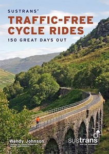
Sustrans` Traffic-Free Cycle Rides: 150 Great Days Out

Published by Sustrans, the creator of the National Cycle Network, this is the official guidebook which brings together 150 of the country`s finest traffic-free walking and cycling routes in celebration of twenty years of the NCN.Offering a unique glimpse into the UK`s remarkable landscapes, history, culture and architecture, the rides range from the wild and ethereal mountain tracks of Snowdonia to fairytale woodland trails through the Forest of Dean and elegant city centre paths linking London`s Royal Parks and palaces.Fully illustrated with maps and photographs, the guide includes routes for all ages and abilities, cycle-friendly places to stay and eat, bike hire centres, public transport links and things to see along the way. There is insightful advice on extending the rides or
connecting to other nearby routes. Inspiring and informative this is a comprehensive guide to traffic-free cycling and a fitting 20th anniversary tribute to the Network Cycle Network. It may be complemented with Sustrans` series of pocket cycle maps where each ride has a suggested wider area map to use.
RIP - This product is no longer available on our network. It was last seen on 25.09.2019

This page now acts as a permanent archive for this product. Add more information using the comments box below to ensure it can still be found by future generations.

Use our search facility to see if it is available from an alternative contributor.
  • Availability: Out Of Stock
  • Supplier: Stanfords
  • SKU: 9781901389968
Availability: In Stock
£15.99

Product Description

Published by Sustrans, the creator of the National Cycle Network, this is the official guidebook which brings together 150 of the country`s finest traffic-free walking & cycling routes in celebration of twenty years of the NCN. Offering a unique glimpse into the UK`s remarkable landscapes, history, culture & architecture, the rides range from the wild & ethereal mountain tracks of Snowdonia to fairytale woodland trails through the Forest of Dean & elegant city centre paths linking London`s Royal Parks & palaces. Fully illustrated with maps & photographs, the guide

Includes::
routes for all ages & abilities, cycle-friendly places to stay & eat, bike hire centres, public transport links & things to see along the way. There is insightful advice on extending the rides or connecting to other nearby routes. Inspiring & informative this is a comprehensive guide to traffic-free cycling & a fitting 20th anniversary tribute to the Network Cycle Network. It may be complemented with Sustrans` series of pocket cycle maps where each ride has a suggested wider area map to use.

Reviews/Comments

Add New

Intelligent Comparison

Oooops!
We couldn't find anything!
Perhaps this product's unique.... Or perhaps we are still looking for comparisons!
Click to bump this page and we'll hurry up.

Price History

Vouchers

No voucher codes found.
Do you know a voucher code for this product or supplier? Add it to Insights for others to use.

Facebook

Jargon Buster

Forest - A area with a high density of trees
UK - United Kingdom - An island nation in Europe
History - Anything that happens in the past. An acedemic subject.
Network - A link and communication between things. Often computers or people.
Pocket - A bag shaped insert in clothing used to carry items
Transport - Something that carries people or goods.

Supplier Information

Stanfords
Stanfords was established in 1853 and opened their iconic Covent Garden flagship store in 1901. They have become the top retailer of maps, travel books and accessories in the UK and arguably offer the largest selection of maps and travel books worldwide. Famous names such as Captain Robert Falcon Scott, Ranulph Fiennes and Michael Palin have purchased from Stanfords. They now have a shop in Bristol and both stores together with other venues operate a calendar of events including talks, book signings and exhibitions. As a specialist map retailer, the map selection is comprehensive and includes road maps, street maps and walking maps from worldwide destinations, as well as a selection of world atlases and wall maps. Books include travel guides and travel literature. Stanfords also stock globes, from miniatures made of blue marble to magnificent floor-standing globes. The website features a selection of interesting articles on travel topics.
Page Updated: 2023-11-12 20:15:36

Community Generated Product Tags

Oh No! The productWIKI community hasn't generated any tags for this product yet!
Menu