
 United Kingdom
 France
 Germany
 Netherlands
 Sweden
 USA
USA
 Italy
Italy
 Spain
Spain
More From Contributor


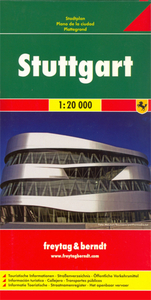
Stuttgart Freytag & Berndt Map
Indexed street map of Stuttgart at 1:20, 000 from Freytag & Berndt with an enlargement of central Stuttgart at 1:10, 000. Mapping is bright, colourful and clear, with one-way streets shown, as well as the U-bahn, S-bahn, bus and rail networks with stops clearly indicated.Points of interest such as the State Gallery, State Theatre, museums, and parks are marked, as are local facilities. The enlargement of the central Stuttgart shares the same mapping but with more clarity, and is indexed along with the main map on the reverse.A diagram of Stuttgart`s VVS Network (U-bahn, S-bahn, bus and train) included. Map legend includes English.

Product Description
Reviews/Comments
Add New
Intelligent Comparison
Archived Product
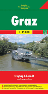
Graz Freytag & Berndt Map Stanfords
£9.99
Archived Product

Elba Freytag & Berndt Map Stanfords
£4.99
Archived Product
St. Polten Freytag & Berndt Map Stanfords
£9.99
Archived Product
Milan Freytag & Berndt Map Stanfords
£9.99
Archived Product

Rügen Freytag & Berndt Map Stanfords
£9.99
Archived Product
Mariazell Freytag & Berndt Map Stanfords
£4.50
Archived Product
Linz Freytag & Berndt Map Stanfords
£9.99
Archived Product
Cologne Freytag & Berndt Map Stanfords
£9.99
Vouchers
No voucher codes found.
Do you know a voucher code for this product or supplier? Add it to Insights for others to use.
Do you know a voucher code for this product or supplier? Add it to Insights for others to use.
 Denmark