
 United Kingdom
 France
 Germany
 Netherlands
 Sweden
 USA
USA
 Italy
Italy
 Spain
Spain
More From Contributor

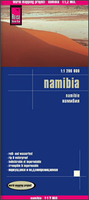
Namibia Reise Know-How
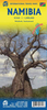
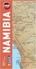
Namibia at 1:1, 200, 000 on an indexed, waterproof and tear-resistant road map with topographic and tourist information, published by Reise Know-How as part of their highly acclaimed World Mapping Project. The map is double-sided to provide the best balance between a good scale and a convenient size sheet; the country is divided north/south with a very generous overlap and Windhoek included on both sides. The eastern Kavango and Zambezi provinces (previously the Caprivi Strip) are shown on an inset.The country’s topography is presented by altitude colouring with contours, spot heights, mountain passes, and names of mountain ranges. The map also shows salt lakes and seasonal rivers. Internal administrative boundaries are shown with names of the provinces. Road network includes
unsurfaced local roads and 4WD tracks, and shows driving distances and locations of petrol stations. Restricted access roads and areas are clearly marked. Border crossings indicate their opening times. Railway lines and local airfields are also shown. National parks and protected zones are clearly marked. Symbols highlight numerous places of interest, including UNESCO world heritage sites, churches and archaeological sites, camping sites, hot springs, viewpoints, etc. Throughout the map numerous locations of tourist accommodation are shown graded into five categories: guest farms and hunting farms; lodges and tented lodges; rest camps and B&Bs; campsites and communal camping; and state-owned rest camps and Namibia Wildlife Resorts. The map has a latitude and longitude grid at
intervals of 1° and index of localities. Map legend includes English.

Product Description
Reviews/Comments
Add New
Vouchers
No voucher codes found.
Do you know a voucher code for this product or supplier? Add it to Insights for others to use.
Do you know a voucher code for this product or supplier? Add it to Insights for others to use.
 Denmark