
 United Kingdom
 France
 Germany
 Netherlands
 Sweden
 USA
USA
 Italy
Italy
 Spain
Spain
More From Contributor

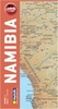
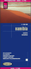

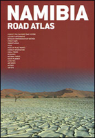
Namibia Map Studio Road Atlas
Road Atlas of Namibia from Map Studio combining coverage of the whole country at 1:500, 000 approx. with more detailed mapping and descriptions of several key tourist areas and towns, plus useful contact addresses, etc.The whole of Namibia, with the part of Botswana adjoining to the Caprivi Strip including the Okavango Delta, is covered at approx. 1:500, 000 on maps with extensive information for route planning. Road network indicates untarred roads and 4WD tracks, shows locations of fuel supplies and vehicle repair facilities, and gives driving distances on most local routes. Important road junctions and locations are annotated with GPS waypoints and, where necessary, entrance gates to protected areas are marked. The atlas also show railway lines, highlighting scenic sections. A
very wide range of symbols indicate locations with various types of tourist accommodation, recreational and wild life watching areas, medical facilities, etc. National parks and other protected areas are prominently highlighted. The maps show rivers, lakes and salt pans, but with altitude indicated only by peak heights and names of mountain ranges. The maps have no geographical coordinates apart form the waypoints.Namibia’s 12 key tourist areas are shown in greater detail on maps accompanied by descriptions. This section includes Etosha, Fish River Canyon, Kaokoland, the Lüderitz Peninsula and Kolmanskop ghost town, Waterberg Plateau Park, etc. Street plans with notes on main sights and local tips cover 20 towns. The atlas is indexed, illustrated with numerous color photos,
and includes a list useful contact details, a general introductory section and a distance table

Product Description
Reviews/Comments
Add New
Vouchers
No voucher codes found.
Do you know a voucher code for this product or supplier? Add it to Insights for others to use.
Do you know a voucher code for this product or supplier? Add it to Insights for others to use.
 Denmark