
 United Kingdom
 France
 Germany
 Netherlands
 Sweden
 USA
USA
 Italy
Italy
 Spain
Spain
More From Contributor

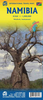
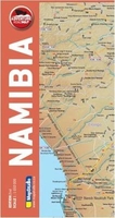
Namibia Map Studio Adventure Map
Namibia on an indexed map from the South African publishers Map Studio annotated numerous places of interest and GPS waypoints for important road junctions, plus a street plan of central Windhoek. The map covers whole country at 1:1, 650, 000, with the Zambezi Region (the new name of the Caprivi Strip) shown as an inset.Road network highlights main routes and clearly shows road numbers for secondary roads and many cross-country tracks. Important road junctions are annotated with GPS waypoints and locations of filling stations and border crossings are marked. Driving distances are shown on main and selected secondary routes. Railway lines are included and local airports are marked. The map also indicates places with tourist accommodation (hotels/motels, caravan and campsites, etc),
medical facilities, and various places of interest. Topography is presented by relief shading. The map shows the boundaries of national parks and game reserves, as well as administrative borders of Namibia’s provinces. Latitude and longitude lines are drawn at 1° intervals. The index is next to the map.Also provided is a street plan of central Windhoek annotated with various places of interest and facilities.
medical facilities, and various places of interest. Topography is presented by relief shading. The map shows the boundaries of national parks and game reserves, as well as administrative borders of Namibia’s provinces. Latitude and longitude lines are drawn at 1° intervals. The index is next to the map.Also provided is a street plan of central Windhoek annotated with various places of interest and facilities.

Product Description
Reviews/Comments
Add New
Vouchers
No voucher codes found.
Do you know a voucher code for this product or supplier? Add it to Insights for others to use.
Do you know a voucher code for this product or supplier? Add it to Insights for others to use.
 Denmark