
 United Kingdom
 France
 Germany
 Netherlands
 Sweden
 USA
USA
 Italy
Italy
 Spain
Spain
More From Contributor


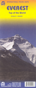
Mount Everest
Mount Everest in a series of maps of Nepal published by the German and Austrian Alpine Clubs as part of their coverage of areas outside Europe. The map, edited in 1957 and last printed in 1999 has contours at 20m intervals, with all peak and spot heights given both in metres and feet. Fewer names of peaks, ridges, glaciers, settlements, etc. are shown than on other maps of this area. The map covers primarily the Nepali side of the Everest massif, extending south to Pangboche and from Changri La in the west to Gangshung Glacier in the east. The Nepal - Tibet border is not marked. Margin ticks give latitude and longitude at intervals of 5
Product Description
Reviews/Comments
Add New
Intelligent Comparison
Archived Product

Mount Everest Stanfords
£22.50
Archived Product
Mount Everest Notebook Stanfords
£9.99
Archived Product
Mount Elbrus Stanfords
£9.95
Archived Product

Monte Ceresa Stanfords
£11.95
Archived Product
Mt Everest ITMB Stanfords
£9.99
Archived Product
Coronation Everest Stanfords
£9.99
Vouchers
No voucher codes found.
Do you know a voucher code for this product or supplier? Add it to Insights for others to use.
Do you know a voucher code for this product or supplier? Add it to Insights for others to use.
 Denmark