
 United Kingdom
 France
 Germany
 Netherlands
 Sweden
 USA
USA
 Italy
Italy
 Spain
Spain
More From Contributor


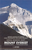

Mount Everest - Himalayas Wall Map
The National Geographic wall map of Mount Everest is an exceptionally clear, detailed and visually stunning 60x96cm map of the highest parts of the Himalayas, centred on Mount Everest, at 1:50, 000 scale. Finely drawn and presented in gentle colouring with relief shading to give a 3-D effect, the overall impression of the mountains, ridges and glaciers is clear and vivid, making it a very attractive wall decoration as well as a high-quality cartographic work.This map features widely-acclaimed cartography drawn by the Swiss national survey organization, and draws data from a number of sources - from the earliest explorers
Product Description
Reviews/Comments
Add New
Vouchers
No voucher codes found.
Do you know a voucher code for this product or supplier? Add it to Insights for others to use.
Do you know a voucher code for this product or supplier? Add it to Insights for others to use.
 Denmark