
 United Kingdom
 France
 Germany
 Netherlands
 Sweden
 USA
USA
 Italy
Italy
 Spain
Spain
More From Contributor


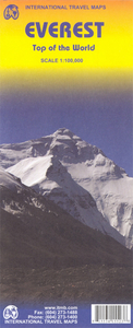
Mt Everest ITMB
Mt Everest region at 1:100, 000 from ITMB on a contoured map with tourist information but with somewhat unusual choice of colouring which makes the whole area appear more like a desert rather the highest mountain range covered in glaciers!Coverage extends from Lukla to beyond the North Base Camp on the Tibetan side. The map has contour lines at 100m intervals, plus additional altitude colouring and graphics for glaciers, moraine, scree, rock and vegetation. Numerous mountain ranges, glaciers, peaks and passes are named.Main Everest trekking routes are marked and symbols highlight various places of interest and tourist facilities. The map has latitude and longitude lines at intervals of 5’ and an indexed of settlements.

Product Description
Reviews/Comments
Add New
Intelligent Comparison
Archived Product
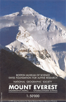
Mount Everest Stanfords
£22.50
Archived Product
Mount Everest Stanfords
£14.50
Vouchers
No voucher codes found.
Do you know a voucher code for this product or supplier? Add it to Insights for others to use.
Do you know a voucher code for this product or supplier? Add it to Insights for others to use.
 Denmark