
 United Kingdom
 France
 Germany
 Netherlands
 Sweden
 USA
USA
 Italy
Italy
 Spain
Spain
More From Contributor


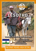

Lesotho
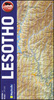
Lesotho at 1: 350, 000 on a GPS-compatible, indexed map from the South African publishers Map Studio, with road information indicating sections which are difficult and/or impassable after heavy rain, plus a street plan of central Maseru, etc.The map shows the topography by altitude colouring with names of mountain ranges and peaks, plus spot heights and symbols for mountain passes. Road network is classified as main roads, other all- or fair-weather roads and 4WD tracks. Also marked are
Product Description
Reviews/Comments
Add New
Vouchers
No voucher codes found.
Do you know a voucher code for this product or supplier? Add it to Insights for others to use.
Do you know a voucher code for this product or supplier? Add it to Insights for others to use.
 Denmark