
 United Kingdom
 France
 Germany
 Netherlands
 Sweden
 USA
USA
 Italy
Italy
 Spain
Spain
More From Contributor


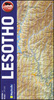
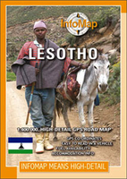
Lesotho InfoMap
Lesotho on a road map from South African publishers International Motoring Productions with GPS waypoints for selected small towns or settlements, road junctions and recommended accommodation or campsites.The map, one of a series of similar maps covering countries and selected regions of southern Africa, has rather simple cartography with somewhat basic elevation tinting, spot heights, rivers and lakes and names of main peaks and mountain ranges. Main protected areas are highlighted.Roads are classified as main, tarred, gravel 2WD or 4WD tracks and show driving distances on selected routes and locations of fuel stations. Border crossings to South Africa are shown with opening times. Local airfields are marked and symbols indicate various places of interest and accommodation.The map
has lists of GPS waypoints for selected villages and road junctions. GPS coordinates are also provided for recommended accommodation, some with contact details and symbols indicating what facilities can be found there.An enlargement shows the Lekhatje/Jobo Mountain area, there is also a basic plan of Maseru with accommodation, facilities, etc. Also included are notes on travelling in the country, customs regulations, etc.
has lists of GPS waypoints for selected villages and road junctions. GPS coordinates are also provided for recommended accommodation, some with contact details and symbols indicating what facilities can be found there.An enlargement shows the Lekhatje/Jobo Mountain area, there is also a basic plan of Maseru with accommodation, facilities, etc. Also included are notes on travelling in the country, customs regulations, etc.

Product Description
Reviews/Comments
Add New
Vouchers
No voucher codes found.
Do you know a voucher code for this product or supplier? Add it to Insights for others to use.
Do you know a voucher code for this product or supplier? Add it to Insights for others to use.
 Denmark