More From Contributor
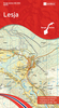
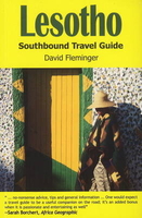
£6.50
The Kalloni area of central part of Lesbos on a detailed, GPS compatible map at 1:33, 000 from Geopsis highlighting locations of 10 wetlands listed by the World Wide Fund for Nature (WWF), five more bird watching sites, plus recommendations for local walks. Coverage of the main map is centred on the town of Skala Kallonis on the coast & extends inland to include Agua Paraskevi & Filra. On the reverse an additional panel shows the Parakoila Forest at 1:52, 000. All place names are in both Greek & Latin alphabet. Topography is presented by contours at 20m intervals with relief shading. The map indicates surfaced roads in poor conditions & dirt tracks, most with driving distances, plus locations of fuel supplies. Icons show tourist accommodation, tavernas, beaches & marinas, cycle hire, etc. The map has a 1-km UTM grid, plus crosshairs for latitude & longitude at 1’. Hiking trails are highlighted & on the reverse are descriptions of three routes, plus recommendations for biking. The map also indicates locations of 10 wetlands listed by the World Wide Fund for Nature (previously World Wildlife Fund), plus five more bird watching sites which have descriptions on the reverse. Map legend & all the text include English. ...
Archived Product
£6.99
The southern part of the Mytilini/ Mitilini/ Mytilene Peninsula on the island of Lesbos on a GPS compatible contoured map at 1:18, 000 from Geopsis printed on light, waterproof & tear-resistant paper. Enlargements & descriptions provide more information for hiking. On one side is a map at 1:18, 000 covering the southern part of the peninsula, south of the town of Varia. Contours at 10m intervals with vivid relief shading are enhanced by colouring and/or graphics showing forests & burnt forests. The map shows the area’s road network & highlights various places of interest including beaches, tourist accommodation, tavernas, bus stops, petrol stations, panoramic views, caves, etc. An overprint indicates seven local hiking routes for which brief descriptions are provided in both Greek & English. The map has a UTM grid, plus latitude & longitude crosshairs. On the reverse the area south of the villages of Taksiarches & Aghia-Marina is shown enlarged to 1:10, 000, with one of the selected routes shown annotated with brief notes. The same route is also presented on a 3-D view of the landscape with contours & various landmarks. Map legend & the text include English. ...
Archived Product
£1.99
Jill Dudley describes Lesbos as lyrical, both in its landscape & its people. It is the birthplace of the poetess Sappho, & the final resting place of Orpheus whose singing was said to be so beautiful that the mountains bowed down & animals drew near to listen. She describes the places where they are remembered on the isl&, & also writes about today`s miracle-working icon at the Taxiarchis Monastery. ...
Archived Product
£23.99
Map No. 10072, Lesja, in the new topographic survey of Norway at 1:50, 000 covering the country on 195 double-sided sheets & first published by Nordeca in 2011
- 2012; fully GPS compatible, indicating waymarked footpaths, campsites, tourist huts, illuminated ski runs, etc. The maps, now published by Nordeca, the successors to Statens Kartverk & its subsequent owners the Ugland Group, are printed on light, waterproof & tear-resistant synthetic paper. Each map covers an area of 62x 45 kilometres (39 x 28 miles approx.), with a 2-km overlap between the sheets. The maps have contours at 20m intervals (10m glacier contours), plus colouring & graphics to show cultivated areas, bogs, forests, etc. In addition to all the information expected of topographic mapping at this scale the maps distinguish between waymarked & unmarked footpaths & show campsites, tourist huts (serviced/self service/no supplies), country hotels & restaurants, & illuminated ski trails. The series uses EUREF89 (WGS84) datum & the maps have a 1-km UTM grid. Map legend is in Norwegian & English. Each title comes in a sturdy protective card envelope.
...
Archived Product
£9.95
Lesotho at 1: 350, 000 on a GPS-compatible, indexed map from the South African publishers Map Studio, with road information indicating sections which are difficult and/or impassable after heavy rain, plus a street plan of central Maseru, etc. The map shows the topography by altitude colouring with names of mountain ranges & peaks, plus spot heights & symbols for mountain passes. Road network is classified as main roads, other all- or fair-weather roads & 4WD tracks. Also marked are ...
Archived Product
£13.99
Lesotho on a road map from South African publishers International Motoring Productions with GPS waypoints for selected small towns or settlements, road junctions & recommended accommodation or campsites. The map, one of a series of similar maps covering countries & selected regions of southern Africa, has rather simple cartography with somewhat basic elevation tinting, spot heights, rivers & lakes & names of main peaks & mountain ranges. Main protected areas are highlighted. Roads are classified as main, tarred, gravel 2WD or 4WD tracks & show driving distances on selected routes & locations of fuel stations. Border crossings to South Africa are shown with opening times. Local airfields are marked & symbols indicate various places of interest & accommodation. The map has lists of GPS waypoints for selected villages & road junctions. GPS coordinates are also provided for recommended accommodation, some with contact details & symbols indicating what facilities can be found there. An enlargement shows the Lekhatje/ Jobo Mountain area, there is also a basic plan of Maseru with accommodation, facilities, etc. Also included are notes on travelling in the country, customs regulations, etc. ...
Archived Product
£10.99
Lesotho at 1: 375, 000 on an indexed map from the South African publishers Map Studio, with GPS coordinates for important road junctions, locations with tourist accommodation or fuel supplies, etc, plus a street plan of central Maseru. The map uses satellite imagery enhanced by altitude colouring to present the topography of this mountainous country. Road network differentiates between tarred & untarred roads &

Includes::
selected tracks. Locations of border crossings & of fuel stations are marked & driving distances are shown on main routes. Many road junctions are annotated with their GPS waypoints. Symbols indicate locations with access by air transport, tourist accommodation including campsites & caravan parks, medical facilities, etc. The map is indexed & has latitude & longitude lines at intervals of 30’. The plan of central Maseru names selected streets & highlights important buildings.

...
Archived Product
£12.99
Topographic survey of France at 1:25, 000 in IGN`s excellent TOP25 / Série Bleue series. All the maps are GPS compatible, with a 1km UTM grid plus latitude & longitude lines at 5’ intervals. Contours are at 5m intervals except for mountainous areas where the maps have contours at 10m intervals, vividly enhanced by hill shading & graphics for rocky terrain. Colouring with graphics indicates different types of vegetation or land use (deciduous or coniferous forests, moors, orchards, vineyards, etc). PLEASE NOTE: coverage of France at this scale is currently being revised – the format & the presentation of each title are indicated by the letters at the end of its Sheet Reference number (e.g. 0416ET, 3531ETR, 1923SB, etc.)MAPS WITH FULL TOURIST OVERPRINT & AN ENGLISH MAP LEGEND: all TOP25 maps & the SB editions of Série Bleue have an overprint highlighting waymarked walking trails including long-distance GR routes &, where appropriate, ski routes. Symbols indicate campsites, gîtes d’etape, refuges, equestrian centres & other recreational facilities or sites, tourist information centres, cultural heritage, etc. Towns & locations of particular interest are highlighted.- ET or OT = single-sided TOP25 map covering approx. 29x 21 km / 18x 13 miles.- ETR or OTR = waterproof & tear resistant TOP25 map covering the same area as the corresponding ET or OT number, but double-sided, printed on a smaller size sheet with a good overlap between the sides.- SB = Série Bleue map with full tourist overprint; these maps, first introduced in summer 2014, each cover approx. 29x 24km / 18x 15 miles.SÉRIE BLEUE maps with numbers ending in E (Est) or O (Ouest): most editions now indicate the GR routes, but do not show any other tourist information. Map legend is in French only. Each map covers approx. 14x 20km / 9x 12 miles. ...
Archived Product

Lesotho

This title is from the mists of Basotho legend - from the time of King Moshoeshoe. The tiny country of Lesotho is entirely surrounded by South Africa, yet it remains one of the most remote and unexplored areas in the region. The reason for this isolation is the mountains - row upon row of serrated peaks make this the country with the highest `low point` in the world. But the mountains that give Lesotho its dramatic landscapes have also played a crucial role in creating a country with a unique history. It`s a stirring story of courage and cunning, featuring remarkable individuals such as King Moshoeshoe - founder of the Basotho nation - who first gathered people together on the flat-topped hill Thaba Bosiu, the mountain of night. Today, Lesotho is an irresistible lure to adventurous
travellers who want to head off the beaten path and tackle the mighty mountains. But Lesotho isn`t as inaccessible as it seems. The country is bisected by a number of tarred and gravel roads and these lead the motorist on jaw-dropping drives through some of the highest mountains this side of Kilimanjaro.Small rural villages nestle on the slopes, much as they have done for over 200 years, and delightful lodges are tucked away in secluded valleys. All in all, it`s a land of secret vistas and pristine scenery. This book is the first travel guide dedicated solely to Lesotho. It will give the traveller an insight into the remarkable history of the country. Suggested itineraries are included, along with accommodation options, leisure activities and other useful information for
trip-planning.
RIP - This product is no longer available on our network. It was last seen on 25.09.2019

This page now acts as a permanent archive for this product. Add more information using the comments box below to ensure it can still be found by future generations.

Use our search facility to see if it is available from an alternative contributor.
  • External links may include paid for promotion
  • Availability: Out Of Stock
  • Supplier: Stanfords
  • SKU: 9781920143268
Availability: In Stock
£13.95

Product Description

This title is from the mists of Basotho legend
- from the time of King Moshoeshoe. The tiny country of Lesotho is entirely surrounded by South Africa, yet it remains one of the most remote & unexplored areas in the region. The reason for this isolation is the mountains
- row upon row of serrated peaks make this the country with the highest `low point` in the world. But the mountains that give Lesotho its dramatic landscapes have also played a crucial role in creating a country with a unique history. It`s a stirring story of courage & cunning, featuring remarkable individuals such as King Moshoeshoe
- founder of the Basotho nation
- who first gathered people together on the flat-topped hill Thaba Bosiu, the mountain of night. Today, Lesotho is an irresistible lure to adventurous travellers who want to head off the beaten path & tackle the mighty mountains. But Lesotho isn`t as inaccessible as it seems. The country is bisected by a number of tarred & gravel roads & these lead the motorist on jaw-dropping drives through some of the highest mountains this side of Kilimanjaro. Small rural villages nestle on the slopes, much as they have done for over 200 years, & delightful lodges are tucked away in secluded valleys. All in all, it`s a land of secret vistas & pristine scenery. This book is the first travel guide dedicated solely to Lesotho. It will give the traveller an insight into the remarkable history of the country. Suggested itineraries are included, along with accommodation options, leisure activities & other useful information for trip-planning.

Reviews/Comments

Add New

Intelligent Comparison

Oooops!
We couldn't find anything!
Perhaps this product's unique.... Or perhaps we are still looking for comparisons!
Click to bump this page and we'll hurry up.

Price History

Vouchers

No voucher codes found.
Do you know a voucher code for this product or supplier? Add it to Insights for others to use.

Facebook

Jargon Buster

South Africa - A country at the southern tip of Africa.
History - Anything that happens in the past. An acedemic subject.
World - A physical grouping, commonly used to describe earth and everything associated with ti
King - The figure head of a monarch
Gravel - A size of rock between 2mm and 64mm
Small - something that takes up less space than normal.
Accommodation - A room in which someone can live in, for example in a hotel
Head - The upper part of a body typically separated by the neck.

Supplier Information

Stanfords
Stanfords was established in 1853 and opened their iconic Covent Garden flagship store in 1901. They have become the top retailer of maps, travel books and accessories in the UK and arguably offer the largest selection of maps and travel books worldwide. Famous names such as Captain Robert Falcon Scott, Ranulph Fiennes and Michael Palin have purchased from Stanfords. They now have a shop in Bristol and both stores together with other venues operate a calendar of events including talks, book signings and exhibitions. As a specialist map retailer, the map selection is comprehensive and includes road maps, street maps and walking maps from worldwide destinations, as well as a selection of world atlases and wall maps. Books include travel guides and travel literature. Stanfords also stock globes, from miniatures made of blue marble to magnificent floor-standing globes. The website features a selection of interesting articles on travel topics.
Page Updated: 2023-11-12 20:15:36

Community Generated Product Tags

Oh No! The productWIKI community hasn't generated any tags for this product yet!
Menu