More From Contributor
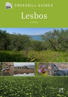
£9.95
Lesbos in the Mc Gilchrist’s Greek Islands series focuses primarily on cultural tourism for the visitor who wishes to understand more about the art, history & architecture of the islands. The series contains no photographs, but has specially drawn maps for each island (66 in total) & site plans for every major site (57 in total), together with thoroughly comprehensive textual information. Each guide also recommends a small number of places to stay & eat selected for their simplicity & unpretentiousness. ...
Archived Product
£10.99
Lesbos at 1:50, 000 on an indexed, GPS compatible map from Freytag & Berndt with brief descriptions of places of interest highlighted on the map, plus a street plan of Mitilini. The map is double-sided, dividing the island east/west, with a very generous overlap between the sides. Topography of the island is shown by bold relief shading, enhanced by contours at 40m intervals. All place names are given in both Greek & Latin alphabet. Road network

Includes::
small local roads & selected cart tracks, showing driving distances on main & secondary routes. Ferry connections are marked. The island’s best sights are prominently highlighted & provided with brief multilingual descriptions in a booklet attached to the map cover. Various other places of interest are marked & named on the map, including numerous beaches & churches/monasteries. The map has a UTM grid, plus latitude & longitude margin ticks. The index, placed in the booklet, provides GPS waypoints for all the locations listed in it. Multilingual map legend

Includes::
English. Also provided is a street plan of Mitilini. Street names are in the Latin alphabet only.


...
Archived Product
£6.99
Lesbos at 1:110, 000 on a road map from Greek publishers Geopsis, annotated with numerous places of interest & facilities. Printed on waterproof & tear-resistant plastic paper, the map

Includes::
a street plan of Mitilini on the reverse. On one side is a road map of the island at 1:110, 000. The base is derived from satellite imagery, enhanced by altitude colouring & relief shading, plus graphics to indicate woodlands & protected areas. Road network included local rural roads, gives driving distances in main routes & shows locations of petrol stations. Also shown are selected hiking routes. A wide range of symbols highlights various places of interest, including thermal springs & waterfalls, wetlands, caves, beaches, sport & recreational facilities, tourist accommodation & tavernas, etc. Place names are in both Greek & Latin alphabet. Latitude & longitude lines are drawn at 5’ intervals. Map legend

Includes::
English. The reverse side shows a street plan of Mitilini at 1:6, 500 annotated with places of interest & various facilities. Names of main streets are in both alphabets, smaller streets are in Greek only.


...
Archived Product
£26.95
Lesbos Hiking Guide in a bilingual English/ Greek edition from Geopsis, with 27 trails shown on coloured, GPS compatible & contoured hiking maps at scales between 1:10, 000 & 1:30, 000, plus an extensive introductory section. The guide describes 24 walks, between 1.5 km & 12.6 km long, in different parts of the isl&, with most trails around Agiasos & Plomari. Also included are three trails crossing the island ...
Archived Product
£6.99
The Aghiasos area of the island of Lesbos on a GPS compatible contoured map at 1:12, 000 from Geopsis printed on light, waterproof & tear-resistant paper. Enlargements & descriptions provide more information for hiking. On one side is a map at 1:12, 000 covering the area around the inland town of Aghiasos. Contours at 10m intervals with vivid relief shading are enhanced by colouring and/or graphics showing forests. The map shows the area’s road network & highlights various places of interest including tavernas, bus stops, petrol stations, panoramic views, caves, etc. An overprint indicates six local hiking routes for which brief descriptions are provided in both Greek & English. The map has a 1-km UTM grid, plus latitude & longitude crosshairs. On the reverse the area immediately south of Aghiasos is shown enlarged to 1:10, 000, with selected routes shown annotated with brief notes. The routes are also presented on a 3-D view of the landscape with contours & various landmarks. Map legend & the text include English. ...
Archived Product
£6.50
The Kalloni area of central part of Lesbos on a detailed, GPS compatible map at 1:33, 000 from Geopsis highlighting locations of 10 wetlands listed by the World Wide Fund for Nature (WWF), five more bird watching sites, plus recommendations for local walks. Coverage of the main map is centred on the town of Skala Kallonis on the coast & extends inland to include Agua Paraskevi & Filra. On the reverse an additional panel shows the Parakoila Forest at 1:52, 000. All place names are in both Greek & Latin alphabet. Topography is presented by contours at 20m intervals with relief shading. The map indicates surfaced roads in poor conditions & dirt tracks, most with driving distances, plus locations of fuel supplies. Icons show tourist accommodation, tavernas, beaches & marinas, cycle hire, etc. The map has a 1-km UTM grid, plus crosshairs for latitude & longitude at 1’. Hiking trails are highlighted & on the reverse are descriptions of three routes, plus recommendations for biking. The map also indicates locations of 10 wetlands listed by the World Wide Fund for Nature (previously World Wildlife Fund), plus five more bird watching sites which have descriptions on the reverse. Map legend & all the text include English. ...
Archived Product
£6.99
The southern part of the Mytilini/ Mitilini/ Mytilene Peninsula on the island of Lesbos on a GPS compatible contoured map at 1:18, 000 from Geopsis printed on light, waterproof & tear-resistant paper. Enlargements & descriptions provide more information for hiking. On one side is a map at 1:18, 000 covering the southern part of the peninsula, south of the town of Varia. Contours at 10m intervals with vivid relief shading are enhanced by colouring and/or graphics showing forests & burnt forests. The map shows the area’s road network & highlights various places of interest including beaches, tourist accommodation, tavernas, bus stops, petrol stations, panoramic views, caves, etc. An overprint indicates seven local hiking routes for which brief descriptions are provided in both Greek & English. The map has a UTM grid, plus latitude & longitude crosshairs. On the reverse the area south of the villages of Taksiarches & Aghia-Marina is shown enlarged to 1:10, 000, with one of the selected routes shown annotated with brief notes. The same route is also presented on a 3-D view of the landscape with contours & various landmarks. Map legend & the text include English. ...
Archived Product
£1.99
Jill Dudley describes Lesbos as lyrical, both in its landscape & its people. It is the birthplace of the poetess Sappho, & the final resting place of Orpheus whose singing was said to be so beautiful that the mountains bowed down & animals drew near to listen. She describes the places where they are remembered on the isl&, & also writes about today`s miracle-working icon at the Taxiarchis Monastery. ...
Archived Product
£23.99
Map No. 10072, Lesja, in the new topographic survey of Norway at 1:50, 000 covering the country on 195 double-sided sheets & first published by Nordeca in 2011
- 2012; fully GPS compatible, indicating waymarked footpaths, campsites, tourist huts, illuminated ski runs, etc. The maps, now published by Nordeca, the successors to Statens Kartverk & its subsequent owners the Ugland Group, are printed on light, waterproof & tear-resistant synthetic paper. Each map covers an area of 62x 45 kilometres (39 x 28 miles approx.), with a 2-km overlap between the sheets. The maps have contours at 20m intervals (10m glacier contours), plus colouring & graphics to show cultivated areas, bogs, forests, etc. In addition to all the information expected of topographic mapping at this scale the maps distinguish between waymarked & unmarked footpaths & show campsites, tourist huts (serviced/self service/no supplies), country hotels & restaurants, & illuminated ski trails. The series uses EUREF89 (WGS84) datum & the maps have a 1-km UTM grid. Map legend is in Norwegian & English. Each title comes in a sturdy protective card envelope.
...
Archived Product
£9.95
Lesotho at 1: 350, 000 on a GPS-compatible, indexed map from the South African publishers Map Studio, with road information indicating sections which are difficult and/or impassable after heavy rain, plus a street plan of central Maseru, etc. The map shows the topography by altitude colouring with names of mountain ranges & peaks, plus spot heights & symbols for mountain passes. Road network is classified as main roads, other all- or fair-weather roads & 4WD tracks. Also marked are ...
Archived Product

Lesbos: Greece

The Greek island of Lesbos is a famous destination for birdwatchers and naturalists. In spring and autumn, the already impressive number of breeding birds swells with the arrival of countless migrants. Less well known but equally attractive are the hiking trails, superb geology and abundance of orchids. The old trails and minor roads between the villages make inviting walks amidst picturesque woodlands, groves and meadows with the blue Aegean never far away.This book covers all these aspects and, like all Crossbill Guides, it answers two questions: What makes this area so special, and how you can see this for yourself. There are descriptions of the flora and fauna, landscape and traditional land use, plus 17 detailed routes and 23 sites with concrete indications on where and how to
find birds, wildlife and flora.
RIP - This product is no longer available on our network. It was last seen on 25.09.2019

This page now acts as a permanent archive for this product. Add more information using the comments box below to ensure it can still be found by future generations.

Use our search facility to see if it is available from an alternative contributor.
  • External links may include paid for promotion
  • Availability: Out Of Stock
  • Supplier: Stanfords
  • SKU: 9789491648083
Availability: In Stock
£23.95

Product Description

The Greek island of Lesbos is a famous destination for birdwatchers & naturalists. In spring & autumn, the already impressive number of breeding birds swells with the arrival of countless migrants. Less well known but equally attractive are the hiking trails, superb geology & abundance of orchids. The old trails & minor roads between the villages make inviting walks amidst picturesque woodlands, groves & meadows with the blue Aegean never far away. This book covers all these aspects &, like all Crossbill Guides, it answers two questions: What makes this area so special, & how you can see this for yourself. There are descriptions of the flora & fauna, landscape & traditional land use, plus 17 detailed routes & 23 sites with concrete indications on where & how to find birds, wildlife & flora.

Reviews/Comments

Add New

Intelligent Comparison

Oooops!
We couldn't find anything!
Perhaps this product's unique.... Or perhaps we are still looking for comparisons!
Click to bump this page and we'll hurry up.

Price History

Vouchers

No voucher codes found.
Do you know a voucher code for this product or supplier? Add it to Insights for others to use.

Facebook

Jargon Buster

Hiking - An outdoor activity envolving walking in nature
Blue - A primary colour
Traditional - Something that has become the same through a period of time and thus repeated.
Traditional - Something that has been around for a while and is repeated regularly.
Autumn - A season which falls between summer and winter.

Supplier Information

Stanfords
Stanfords was established in 1853 and opened their iconic Covent Garden flagship store in 1901. They have become the top retailer of maps, travel books and accessories in the UK and arguably offer the largest selection of maps and travel books worldwide. Famous names such as Captain Robert Falcon Scott, Ranulph Fiennes and Michael Palin have purchased from Stanfords. They now have a shop in Bristol and both stores together with other venues operate a calendar of events including talks, book signings and exhibitions. As a specialist map retailer, the map selection is comprehensive and includes road maps, street maps and walking maps from worldwide destinations, as well as a selection of world atlases and wall maps. Books include travel guides and travel literature. Stanfords also stock globes, from miniatures made of blue marble to magnificent floor-standing globes. The website features a selection of interesting articles on travel topics.
Page Updated: 2023-11-12 20:15:36

Community Generated Product Tags

Oh No! The productWIKI community hasn't generated any tags for this product yet!
Menu