More From Contributor
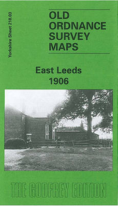
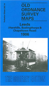
£9.09
Map No. 104, Leeds & Bradford, in the waterproof & tear-resistant OS Active version of the Ordnance Survey Landranger series at 1:50, 000, including Harrogate, Halifax, Sowerby Bridge, Ell&, Batley, Dewsbury, Ossett, Wakefield, Stanley, Morley, Cleckheaton, Mytholmroyd, Queensbury, Shelf, New Farnley, Rothwell, Swillington, Pudsey, Shipley, Thornton, Oxenhope, Haworth, Bingley, Rawdon, Horsforth, Scholes, Thorner, Harewood, Guiseley, Baildon, Keithley, Menston, Otley, Ilkley, Silsden, Denton, Farnley, Huby, Collingham, Spofforth, Follifoot, Beckwithshaw, Addingham, Embsay, Bolton Abbey, Brebley, Bluberhouses, Thornthwaite & Knaresborough, with the south-eastern tip of the Yorkshire Dales National Park. Edition C4; Publication date April 2012 About Ordnance Survey ...
Archived Product
£10.39
Map No. 104, Leeds & Bradford, in a waterproof & tear-resistant version of the Ordnance Survey Landranger series at 1:50, 000, including Harrogate, Halifax, Sowerby Bridge, Ell&, Batley, Dewsbury, Ossett, Wakefield, Stanley, Morley, Cleckheaton, Mytholmroyd, Queensbury, Shelf, New Farnley, Rothwell, Swillington, Pudsey, Shipley, Thornton, Oxenhope, Haworth, Bingley, Rawdon, Horsforth, Scholes, Thorner, Harewood, Guiseley, Baildon, Keithley, Menston, Otley, Ilkley, Silsden, Denton, Farnley, Huby, Collingham, Spofforth, Follifoot, Beckwithshaw, Addingham, Embsay, Bolton Abbey, Brebley, Bluberhouses, Thornthwaite & Knaresborough, with the south-eastern tip of the Yorkshire Dales National Park. Edition C3; Revised for selected changes 2006; Copyright date 2006 This title is also available on our website in a paper version. Maps in this series are only published folded. Stanfords can also print flat versions of Ordnance Survey maps through the OS Select system, centring the map on a location of your choice & with a picture provided by you on the cover. For more information please click on the link at the bottom of this description. About Ordnance Survey ...
Archived Product
£4.95
Leeds & Liverpool Canal by GEOproject shows details of navigation & facilities available to the boat user with details of boatyard & boat trip operators, as well as useful snippets of visitor information for places of interest not far from the water ...
Archived Product
£4.50
Leeds Central & North East in 1890 in a fascinating series of reproductions of old Ordnance Survey plans in the Alan Godfrey Editions, ideal for anyone interested in the history of their neighbourhood or family. Two versions have been published for this area. The map captures much of central Leeds, together with the Burmantofts & Sheepscar areas. Coverage stretches from the Town Hall eastward to Stoney Rock Lane & Leeds Cemetery, & from Bond Street & Commercial Street northward to New Camp Road & Chapeltown Barracks. Major streets near the centre include East Parade, Park Lane, Park Row, Briggate, Vicar Lane & North Street. Kirkgate Market is at the very foot of the map. Areas noted include Little London, The Leylands, Mawson Field, Bagby Fields (top left corner), Mabgate, Sheepscar, New Town, Primrose Hill & Burmantofts. Features include St Mary`s church, Leeds Union Workhouse, St John`s church, Elmwood Mills, St Ann`s RC Cathedral, Burmantofts Brick Works, Burmantofts terra cotta Works, Stanley Road tram depot, Sheepscar Dye Works, etc. Part of Marsh Lane Goods Station is at the foot of the map but most railways are south of this sheet. On the reverse of each map is a selection of street directory entries. The 1890 version is colour-printed, taken from the beautiful h&-coloured OS 1st Edition. About the Alan Godfrey Editions of the 25” OS Series: Selected towns in Great Britain & Ireland are covered by maps showing the extent of urban development in the last decades of the 19th & early 20th century. The plans have been taken from the Ordnance Survey mapping & reprinted at about 15 inches to one mile (1:4, 340). On the reverse most maps have historical notes & many also include extracts from contemporary directories. Most maps cover about one mile (1.6kms) north/south, one & a half miles (2.4kms) across; adjoining sheets can be combined to provide wider coverage.FOR MORE INFORMATION & A COMPLETE LIST OF ALL AVAILABLE TITLES PLEASE CLICK ON THE SERIES LINK. ...
Archived Product
£3.50
Leeds Central & North East in 1906 in a fascinating series of reproductions of old Ordnance Survey plans in the Alan Godfrey Editions, ideal for anyone interested in the history of their neighbourhood or family. Two versions have been published for this area. The map captures much of central Leeds, together with the Burmantofts & Sheepscar areas. Coverage stretches from the Town Hall eastward to Stoney Rock Lane & Leeds Cemetery, & from Bond Street & Commercial Street northward to New Camp Road & Chapeltown Barracks. Major streets near the centre include East Parade, Park Lane, Park Row, Briggate, Vicar Lane & North Street. Kirkgate Market is at the very foot of the map. Areas noted include Little London, The Leylands, Mawson Field, Bagby Fields (top left corner), Mabgate, Sheepscar, New Town, Primrose Hill & Burmantofts. Features include St Mary`s church, Leeds Union Workhouse, St John`s church, Elmwood Mills, St Ann`s RC Cathedral, Burmantofts Brick Works, Burmantofts terra cotta Works, Stanley Road tram depot, Sheepscar Dye Works, etc. Part of Marsh Lane Goods Station is at the foot of the map but most railways are south of this sheet. On the reverse of each map is a selection of street directory entries. The 1890 version is colour-printed, taken from the beautiful h&-coloured OS 1st Edition. About the Alan Godfrey Editions of the 25” OS Series: Selected towns in Great Britain & Ireland are covered by maps showing the extent of urban development in the last decades of the 19th & early 20th century. The plans have been taken from the Ordnance Survey mapping & reprinted at about 15 inches to one mile (1:4, 340). On the reverse most maps have historical notes & many also include extracts from contemporary directories. Most maps cover about one mile (1.6kms) north/south, one & a half miles (2.4kms) across; adjoining sheets can be combined to provide wider coverage.FOR MORE INFORMATION & A COMPLETE LIST OF ALL AVAILABLE TITLES PLEASE CLICK ON THE SERIES LINK. ...
Archived Product
£3.50
Leeds Harehills in 1906 in a fascinating series of reproductions of old Ordnance Survey plans in the Alan Godfrey Editions, ideal for anyone interested in the history of their neighbourhood or family. The map covers part of northern Leeds, stretching from Woodhouse Street eastward to Harehills Road & northward to Potternewton Lane. Areas covered include Harehills, New Leeds, Potternewton Park, Woodhouse Carr, Buslingthorpe & Scott Hall. Industry features, mostly in the south-western corner, include Buslingthorpe Tannery, Perseverance Mill, Ridge Mill, Springwell Leather Works, Sheepscar Leather & Glue Works, Valley Mills, Buslingthorpe Boot Works & Scott Hall Quarries. The rest of the map is largely residential & features include Potternewton House, Scott Hall Farm, St Martin`s church, Newton Park, Newton Green Hall, The Mansion (in Potternewton Park), Gledhow Mount, Gledhow Wood, etc. On the reverse are street directory entries for Cowper Street, Francis Street, Grange Avenue, Harehills Avenue, Leopold Street, Louis Street, Sholebroke Avenue & Woodhouse Street. About the Alan Godfrey Editions of the 25” OS Series: Selected towns in Great Britain & Ireland are covered by maps showing the extent of urban development in the last decades of the 19th & early 20th century. The plans have been taken from the Ordnance Survey mapping & reprinted at about 15 inches to one mile (1:4, 340). On the reverse most maps have historical notes & many also include extracts from contemporary directories. Most maps cover about one mile (1.6kms) north/south, one & a half miles (2.4kms) across; adjoining sheets can be combined to provide wider coverage.FOR MORE INFORMATION & A COMPLETE LIST OF ALL AVAILABLE TITLES PLEASE CLICK ON THE SERIES LINK. ...
Archived Product
£3.50
Headrow area of Leeds in 1847 in a series of exceptionally detailed reproductions of old Ordnance Survey street plans for areas of larger cities which have undergone substantial redevelopment in the late 19th or the early 20th century, published in the Alan Godfrey Editions. The plans, printed in back & white, have been taken from the original Ordnance Survey mapping at 1:1, 056 & reproduced at 1:1, 760 – the equivalent of 36 inches (or one yard) to a mile. The maps provide an unrivalled, house-by-house picture of streets & individual buildings with inner courtyards, outbuildings, pavements, covered passages, etc. Many important institutions are named; within the National Galley on Trafalgar Square even the individual rooms (the map is from 1871, so no French Impressionists as yet!). On the reverse are historical notes about the area covered by the map, plus extracts from contemporary street directories. These maps provide a fascinating addition to Alan Godfrey’s huge series of some 2, 000 titles presenting reproductions of street plans at taken from the Ordnance Survey mapping at 1:2, 500 (25” to 1 mile) & reprinted at about 15 inches to one mile (1:4, 340). ...
Archived Product
£3.50
Lower Briggate area of Leeds in 1847 in a series of exceptionally detailed reproductions of old Ordnance Survey street plans for areas of larger cities which have undergone substantial redevelopment in the late 19th or the early 20th century, published in the Alan Godfrey Editions. The plans, printed in back & white, have been taken from the original Ordnance Survey mapping at 1:1, 056 & reproduced at 1:1, 760 – the equivalent of 36 inches (or one yard) to a mile. The maps provide an unrivalled, house-by-house picture of streets & individual buildings with inner courtyards, outbuildings, pavements, covered passages, etc. Many important institutions are named; within the National Galley on Trafalgar Square even the individual rooms (the map is from 1871, so no French Impressionists as yet!). On the reverse are historical notes about the area covered by the map, plus extracts from contemporary street directories. These maps provide a fascinating addition to Alan Godfrey’s huge series of some 2, 000 titles presenting reproductions of street plans at taken from the Ordnance Survey mapping at 1:2, 500 (25” to 1 mile) & reprinted at about 15 inches to one mile (1:4, 340). ...
Archived Product
£4.50
Leeds North West in 1889 in a fascinating series of reproductions of old Ordnance Survey plans in the Alan Godfrey Editions, ideal for anyone interested in the history of their neighbourhood or family. Two versions have been published for this area. The maps covers the west & north-west of Leeds, encompassing a portion of the city centre, industry along the River Aire, the area now covered by the University, & residential areas of Burley & Woodhouse. Coverage stretches from Salisbury Road & Burley Grange eastward to Park Square & Vernon Road, & from Wellington Street & York Place northward to Brudenell Street & Royal Park Road. Kirkstall Road, Burley Road & Belle Vue Road run through the map. Features include the River Aire with many industries nearby, Armley Mills, Leeds & Liverpool Canal, Albion ammunition works, Wellington Foundry, Leeds Forge, Scotch Foundry, Oak Tannery, Joppa tannery, stretches of the Midland & Leeds Northern railway approaches, portion of Armley (bottom left corner), Burley Lawn, Little Woodhouse, General Infirmary, Catholic College, Yorkshire College (later Leeds University), Trinity church, St George`s church, General Cemetery, etc. On the reverse are extracts from street directories. The 1889 version is in full colour. About the Alan Godfrey Editions of the 25” OS Series: Selected towns in Great Britain & Ireland are covered by maps showing the extent of urban development in the last decades of the 19th & early 20th century. The plans have been taken from the Ordnance Survey mapping & reprinted at about 15 inches to one mile (1:4, 340). On the reverse most maps have historical notes & many also include extracts from contemporary directories. Most maps cover about one mile (1.6kms) north/south, one & a half miles (2.4kms) across; adjoining sheets can be combined to provide wider coverage.FOR MORE INFORMATION & A COMPLETE LIST OF ALL AVAILABLE TITLES PLEASE CLICK ON THE SERIES LINK. ...
Archived Product
£2.95
Leeds North West in 1908 in a fascinating series of reproductions of old Ordnance Survey plans in the Alan Godfrey Editions, ideal for anyone interested in the history of their neighbourhood or family. Selected towns in Great Britain & Ireland are covered by maps showing the extent of urban development in the last decades of the 19th & early 20th century. In this title: two versions have been published for this area. The maps covers the west & north-west of Leeds, encompassing a portion of the city centre, industry along the River Aire, the area now covered by the University, & residential areas of Burley & Woodhouse. Coverage stretches from Salisbury Road & Burley Grange eastward to Park Square & Vernon Road, & from Wellington Street & York Place northward to Brudenell Street & Royal Park Road. Kirkstall Road, Burley Road & Belle Vue Road run through the map. Features include the River Aire with many industries nearby, Armley Mills, Leeds & Liverpool Canal, Albion ammunition works, Wellington Foundry, Leeds Forge, Scotch Foundry, Oak Tannery, Joppa tannery, stretches of the Midland & Leeds Northern railway approaches, portion of Armley (bottom left corner), Burley Lawn, Little Woodhouse, General Infirmary, Catholic College, Yorkshire College (later Leeds University), Trinity church, St George's church, General Cemetery. On the reverse are extracts from street directories. The 1889 version is in full colour. About the Alan Godfrey Editions of the 25 ...
Archived Product

Leeds East 1906

Leeds East in 1906 in a fascinating series of reproductions of old Ordnance Survey plans in the Alan Godfrey Editions, ideal for anyone interested in the history of their neighbourhood or family. The map covers the eastern fringe of Leeds, including the developing area around Harehills Lane and southward along York Road. On the east of these are Harehills Cemetery and Harehills Recreation Ground. Coverage then extends eastward through what was still open country to Killingbeck Smallpox Hospital and Killingbeck Hall. Other features include the tramway along York Road to Halton Dial, Broom Hill Farm, York Road Iron Works, Osmondthorpe Old Hall, and Whitebeck. A selection of street directory entries is on the reverse: Bellbrooke Avenue/Grove/Place, Compton Road, Dawlish
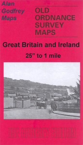
Avenue/Mount/Road, Harehills Lane, Nowell Crescent/Grove/Lane/Mount and Osmondthorpe Lane.About the Alan Godfrey Editions of the 25” OS Series:Selected towns in Great Britain and Ireland are covered by maps showing the extent of urban development in the last decades of the 19th and early 20th century. The plans have been taken from the Ordnance Survey mapping and reprinted at about 15 inches to one mile (1:4, 340). On the reverse most maps have historical notes and many also include extracts from contemporary directories. Most maps cover about one mile (1.6kms) north/south, one and a half miles (2.4kms) across; adjoining sheets can be combined to provide wider coverage.FOR MORE INFORMATION AND A COMPLETE LIST OF ALL AVAILABLE TITLES PLEASE CLICK ON THE SERIES LINK.
RIP - This product is no longer available on our network. It was last seen on 25.09.2019

This page now acts as a permanent archive for this product. Add more information using the comments box below to ensure it can still be found by future generations.

Use our search facility to see if it is available from an alternative contributor.
  • Availability: Out Of Stock
  • Supplier: Stanfords
  • SKU: 9780850549928
Availability: In Stock
£3.50

Product Description

Leeds East in 1906 in a fascinating series of reproductions of old Ordnance Survey plans in the Alan Godfrey Editions, ideal for anyone interested in the history of their neighbourhood or family. The map covers the eastern fringe of Leeds, including the developing area around Harehills Lane & southward along York Road. On the east of these are Harehills Cemetery & Harehills Recreation Ground. Coverage then extends eastward through what was still open country to Killingbeck Smallpox Hospital & Killingbeck Hall. Other features include the tramway along York Road to Halton Dial, Broom Hill Farm, York Road Iron Works, Osmondthorpe Old Hall, & Whitebeck. A selection of street directory entries is on the reverse: Bellbrooke Avenue/ Grove/ Place, Compton Road, Dawlish Avenue/ Mount/ Road, Harehills Lane, Nowell Crescent/ Grove/ Lane/ Mount & Osmondthorpe Lane. About the Alan Godfrey Editions of the 25” OS Series: Selected towns in Great Britain & Ireland are covered by maps showing the extent of urban development in the last decades of the 19th & early 20th century. The plans have been taken from the Ordnance Survey mapping & reprinted at about 15 inches to one mile (1:4, 340). On the reverse most maps have historical notes & many also include extracts from contemporary directories. Most maps cover about one mile (1.6kms) north/south, one & a half miles (2.4kms) across; adjoining sheets can be combined to provide wider coverage.FOR MORE INFORMATION & A COMPLETE LIST OF ALL AVAILABLE TITLES PLEASE CLICK ON THE SERIES LINK.

Reviews/Comments

Add New

Price History

Vouchers

No voucher codes found.
Do you know a voucher code for this product or supplier? Add it to Insights for others to use.

Facebook

Jargon Buster

Contemporary - Modern era design
Contemporary - A design reference to indicate post war modern design
iron - An electrical deviced used for removing creases from fabrics
iron - A chemical element (FE). The most common element on earth
History - Anything that happens in the past. An acedemic subject.
Road - a manmade lane or a path that is used to speed up travel.
Contemporary - An object that is living in the same time.
Hall - A room at the inside of an entrance of a house.
Ideal - Something that satisfies a perfect criteria.
Family - A group of people that live together made up from parents and children.

Supplier Information

Stanfords
Stanfords was established in 1853 and opened their iconic Covent Garden flagship store in 1901. They have become the top retailer of maps, travel books and accessories in the UK and arguably offer the largest selection of maps and travel books worldwide. Famous names such as Captain Robert Falcon Scott, Ranulph Fiennes and Michael Palin have purchased from Stanfords. They now have a shop in Bristol and both stores together with other venues operate a calendar of events including talks, book signings and exhibitions. As a specialist map retailer, the map selection is comprehensive and includes road maps, street maps and walking maps from worldwide destinations, as well as a selection of world atlases and wall maps. Books include travel guides and travel literature. Stanfords also stock globes, from miniatures made of blue marble to magnificent floor-standing globes. The website features a selection of interesting articles on travel topics.
Page Updated: 2023-11-12 20:15:36

Community Generated Product Tags

Oh No! The productWIKI community hasn't generated any tags for this product yet!
Menu