More From Contributor

£4.99
This folded sheet map shows the detailed road network with toll motorways & dual carriageways clearly identified. As well as presenting an array of places of interest for tourists & locals alike, the mapping

Includes::
motorway service areas, AA-inspected campsites & AA-listed golf courses. Gaeltacht regions are highlighted with place names shown in both English & Irish. The map

Includes::
6 city plans of Dublin, Belfast, Cork, Derry Londonderry, Sligo & Waterford. in addition, a separate map of Ireland features relief shading with key physical landmarks.


...
Archived Product
£9.99
Ireland at 1:385, 000 approx. in a series of Adventure maps from the National Geographic Society with cartography provided by Reise Know-How. The map is printed on light waterproof & tear-resistant synthetic paper & is double-sided, with Dublin & Galway included on both sides. Cartographic information provided by Reise Know-How has been adjusted to follow the house style of the NGS Adventure series, with contours at 50m intervals enhanced by relief shading. National parks & other protected areas are highlighted. Road network

Includes::
selected paved & enhanced roads & shows driving distances on main & secondary routes. Railway lines & ferry connections to Britain are included & local airports are marked. Also shown are county names & boundaries. Symbols indicate various places of interest including campsites, golf courses, etc. The map is indexed & has latitude & longitude lines at 20’ intervals.

...
Archived Product
£8.49
Panorama map of Ireland published by Fir Tree Cottage Studio & drawn by Richard Chandler, with 23 mountain & hill rages cross-referenced to list of names & heights. The map also shows the border between Eire & Northern Irel&, county names & boundaries, plus main railway & road connections. ...
Archived Product
£30.00
Astounding aerial photographs revealing an immense & unsuspected wealth of color hidden behind Ireland`s green facade. Yellow islands of gorse, the turquoise edges of the western coast, the algae borders of the winter lakes varying in color from green to orange, deserted islands overgrown with rust brown ferns & deserts of black peat bogs. ...
Archived Product
£8.99
Ireland Awakening by Edward Rutherfurd retells the story of the Emerald Isle from the seventeenth century onwards, beginning with the Reformation & the devastating arrival of Oliver Cromwell, whose arrival inaugurates two hundred years of Protestant dominance throughout which many of the Irish people were impoverished & dispossessed, Dublin was made a protestant capital & Catholics became an underclass. ...
Archived Product
£9.99
Clear, detailed road atlas of Ireland in a handy A4 spiral-bound format. This comprehensive, general purpose road atlas of the whole of Ireland is ideal for both business & pleasure use. The atlas contains a range of mapping scales:* 9 miles to 1 inch route planning map* Main maps at 3.2 miles to 1 inch, which are ideal for navigation.* A wide selection of detailed town centre street plans. This edition boasts road mapping packed with detail
- showing colour classified road network, toll roads, land heights, the location of safety cameras, Blue Flag & Green Coast beaches, tourist information centres & a wide range of tourist attractions. There is also comprehensive guide information for visitors to Belfast, Cork, Dublin & Limerick. The locations of Speed Enforcement Zones, which highlight roads that have a high risk of accidents as identified by the Garda & the National Roads Authority, are included. There is also a wide range of fully indexed town & city centre maps. These are: Bangor, Belfast, Cork, Drogheda, Dublin, Dun Laoghaire, Galway, Kilkenny, Killarney, Limerick, Lisburn, Londonderry (Derry), Newry, Newtownabbey & Waterford.
...
Archived Product
£4.99
Ireland on waterproof & tear-resistant, easy-to-use concertina map at 1:630, 000 / 1” to 10 miles, which opens into individual 17x 23cm panels. Road network is shown on a base with altitude colouring providing very clear indication of the country’s topography. Driving distances are marked on main routes in both miles & kilometres. Railway lines are not included. Symbols highlight various places of interest, including Blue Flag & Green Coast beaches. Current edition of this title was published in March 2014. The map

Includes::
street plans of central Dublin & Belfast, plus a distance table in kilometres & miles.

...
Archived Product
£4.99
Ireland Handy Road Atlas from Collins at 1:588, 235 (1” to 9.3 miles) in an A5 paperback format, with six indexed city centre street plans, descriptions of places of interest, a map showing best beaches, contact details for tourist information centres, airports & ferry companies, etc. The atlas shows the whole country spread on 18 pages, presenting its road & rail networks on mapping with altitude colouring, spot heights, plenty of names of topographic features such as mountain ranges, peaks, etc, plus additional colouring and/or graphics for national parks & beaches. Presentation of the road network

Includes::
full or limited motorway junctions, steep gradients, Speed Enforcement Zones (Eire) or average speed cameras (NI), etc. Railway lines are not

Includes::
, but the maps do show airports, car and/or passenger ferry connections, as well as county or district boundaries. Symbols indicate various places of interest, including historical & cultural sites, nature reserves, Blue Flag and/or Green Coast beaches, etc. The maps have no geographical coordinates. The index highlights places of interest in bold print. Current edition of this title was published in March 2016. The atlas also
Includes:: street plans of central Dublin, Cork, Galway, Limerick, Belfast & Londonderry (Derry), all with indexes also listing places of interest; a map of showing locations of 43 Green Coast beaches & 82 Blue Flag Beaches; descriptions of places of interest cross-referenced to the map pages; panels with contact details for tourist information centres, airports & ferry companies; a distance table in kilometres & miles; an administrative map showing present day counties & the four traditional Provinces. To see the other formats of road atlases of Ireland from Collins, please click on the series link.


...
Archived Product
£4.99
Explore Ireland with this handy format route-planning atlas in full colour, complete with information on places of tourist interest. There are also fully indexed town centre plans of Belfast, Cork, Dublin, Galway, Limerick & Londonderry. This atlas, at A5 size, contains mapping of the whole of Ireland at 9 miles to 1 inch (1:570, 240). The mapping is beautifully designed with colour classified roads & subtle layered height tinting. The atlas is ideal for residents, visitors & tourists alike. Key features of the atlas include:* All Ireland route planning maps.* Dublin, Belfast, Cork, Galway, Londonderry & Limerick town centre plans.* Blue Flag & Green Coast beaches map.* List of tourist information centres.* Description of places of interest.* Full index to place names & places of interest.* Information on airports, ferries & radio stations.* Mileage chart. ...
Archived Product
£2.99
Handy little full colour map of Ireland at an excellent price. It is double-sided, with the south of Ireland up to & including Dublin on one side, & from Dublin northwards on the other. Ideal for the pocket, bag or glovebox of the car.
Includes:* All the latest road changes* Places of interest* Ferry routes* Speed enforcement zones & safety camera locations SCALE1:470, 0007.5 miles to 1 inch.
...
Archived Product

Ireland Borch

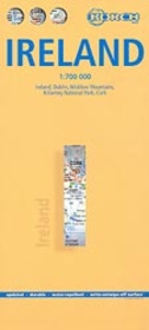
Indexed road map of Ireland published by Borch on laminated and tear-resistant paper. Cork & Dublin street plans, and more detailed maps of Killarney NP & the Wicklow Mts are on the reverse. Road detail extends from motorways to secondary roads, with intermediate driving distances indicated on major routes. Main railways and ferry links are marked.Relief is depicted by hill-shading with some peak heights marked. National parks and nature reserves are indicated, and symbols depict airports, sites of interest, various antiquities, churches, lighthouses and golf courses. Selected major locations are named in Gaelic as well as English. Although county borders are not marked, there is a small administrative map on the reverse showing this information.Also on the reverse are street plans
of central Dublin and Cork, indicating landmarks, attractions, car parks and one-way streets. Two more maps show Killarney National Park and the Wicklow Mountains in more detail, at 1:100, 000 and 1:350, 000 respectively. All these maps are indexed. Multilingual map legend includes English, but not Gaelic.
RIP - This product is no longer available on our network. It was last seen on 25.09.2019

This page now acts as a permanent archive for this product. Add more information using the comments box below to ensure it can still be found by future generations.

Use our search facility to see if it is available from an alternative contributor.
  • External links may include paid for promotion
  • Availability: Out Of Stock
  • Supplier: Stanfords
  • SKU: 9783866093232
Availability: In Stock
£9.99

Product Description

Indexed road map of Ireland published by Borch on laminated & tear-resistant paper. Cork & Dublin street plans, & more detailed maps of Killarney NP & the Wicklow Mts are on the reverse. Road detail extends from motorways to secondary roads, with intermediate driving distances indicated on major routes. Main railways & ferry links are marked. Relief is depicted by hill-shading with some peak heights marked. National parks & nature reserves are indicated, & symbols depict airports, sites of interest, various antiquities, churches, lighthouses & golf courses. Selected major locations are named in Gaelic as well as English. Although county borders are not marked, there is a small administrative map on the reverse showing this information. Also on the reverse are street plans of central Dublin & Cork, indicating landmarks, attractions, car parks & one-way streets. Two more maps show Killarney National Park & the Wicklow Mountains in more detail, at 1:100, 000 & 1:350, 000 respectively. All these maps are indexed. Multilingual map legend

Includes::
English, but not Gaelic.

Reviews/Comments

Add New

Price History

Vouchers

No voucher codes found.
Do you know a voucher code for this product or supplier? Add it to Insights for others to use.

Facebook

Jargon Buster

Cork - A county in Ireland
Cork - A natural product from the Cork Oak tree
Paper - A thin sheet mainly used for writing. Available in a variety of colours. Made mainly from wood pulp.
Railways - A set of tracks that have been laid for the purpose of trains to travel up and down them
Car - A machine used for transport which runs on roads
Small - something that takes up less space than normal.
Road - a manmade lane or a path that is used to speed up travel.
Resistant - Something that can repel against something.
Golf - A sport played on a large outside grass course, the aim to hit a small ball with a club into small holes.
Laminated - A thin layer of plastic that gives a coating and shine to a material.
Borders - A line that sometimes can be built up separating off an area, e.g. countries "the welsh boarder"

Supplier Information

Stanfords
Stanfords was established in 1853 and opened their iconic Covent Garden flagship store in 1901. They have become the top retailer of maps, travel books and accessories in the UK and arguably offer the largest selection of maps and travel books worldwide. Famous names such as Captain Robert Falcon Scott, Ranulph Fiennes and Michael Palin have purchased from Stanfords. They now have a shop in Bristol and both stores together with other venues operate a calendar of events including talks, book signings and exhibitions. As a specialist map retailer, the map selection is comprehensive and includes road maps, street maps and walking maps from worldwide destinations, as well as a selection of world atlases and wall maps. Books include travel guides and travel literature. Stanfords also stock globes, from miniatures made of blue marble to magnificent floor-standing globes. The website features a selection of interesting articles on travel topics.
Page Updated: 2023-11-12 20:15:36

Community Generated Product Tags

Oh No! The productWIKI community hasn't generated any tags for this product yet!
Menu