
 United Kingdom
 France
 Germany
 Netherlands
 Sweden
 USA
USA
 Italy
Italy
 Spain
Spain
More From Contributor


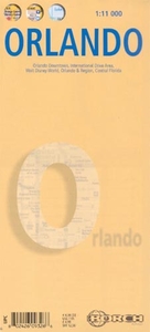
Orlando Borch
Very clear, indexed street plan on durable laminated paper showing downtown Orlando at 1:11, 000, plus the local attractions of the International Drive area and Disney World. Detail includes one-way streets, notable buildings, hotels, shopping malls and railway lines. Symbols denote information centres, monuments, places of worship, theatres, sites of interest, car parks, bus stations, etc.The Downtown map coverage extends from Lake Doone district in the southwest to Lake Estelle and Lake Rowena in the north east, thus including the CBD and Expo Centre. The International Drive Area inset at 1:25, 000 extends from Universal Studios to Sea World and shows all the tourist sites in between. On the reverse is the 1;25, 000 map of Disney World and surrounding resorts, including
Magic Kingdom. There is also a road map at 1:200, 000 of the greater Orlando area (including the airport) and a 1:1, 200, 000 map of central Florida from coast to coast, including the Tampa Bay area. Thirty recommended attractions are highlighted on the maps. All the maps are indexed for streets, locations and places of interest.
Magic Kingdom. There is also a road map at 1:200, 000 of the greater Orlando area (including the airport) and a 1:1, 200, 000 map of central Florida from coast to coast, including the Tampa Bay area. Thirty recommended attractions are highlighted on the maps. All the maps are indexed for streets, locations and places of interest.

Product Description
Reviews/Comments
Add New
Intelligent Comparison
Archived Product
Ireland Borch Stanfords
£9.99
Archived Product
Oslo Borch Stanfords
£8.99
Archived Product
Thailand Borch Stanfords
£9.99
Archived Product

New Orleans Borch Stanfords
£8.99
Archived Product
Switzerland Borch Stanfords
£9.99
Archived Product
Berlin Borch Stanfords
£8.99
Archived Product
France Borch Stanfords
£9.99
Archived Product
London Borch Stanfords
£8.99
Vouchers
No voucher codes found.
Do you know a voucher code for this product or supplier? Add it to Insights for others to use.
Do you know a voucher code for this product or supplier? Add it to Insights for others to use.
 Denmark