
 United Kingdom
 France
 Germany
 Netherlands
 Sweden
 USA
USA
 Italy
Italy
 Spain
Spain
More From Contributor


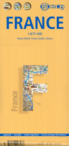
France Borch
Laminated, waterproof and tear resistant, indexed road map of France at 1:875, 000 from Borch, ideal for route-planning. The map is double-sided, dividing the country north/south and, to allow for an excellent scale on a reasonable size sheet, Brittany in the northern half and the Biarritz/Spanish border area in the south are shown on insets. France’s extensive motorway network stands out prominently against the background of other roads and geographical information, with junction numbers and various facilities clearly marked. Connecting local roads are easy to see and many places of interest are highlighted. The map has no geographical coordinates. Map legend includes English.*Please note:* place names in the extensive index of localities are in very small print.

Product Description
Reviews/Comments
Add New
Intelligent Comparison
Archived Product
Florence Borch Stanfords
£8.99
Archived Product
Prague Borch Stanfords
£8.99
Archived Product

Venice Borch Stanfords
£8.99
Archived Product
Vancouver Borch Stanfords
£8.99
Archived Product
France Northern Stanfords
£5.99
Archived Product
France Northern Stanfords
£6.99
Archived Product
Ireland Borch Stanfords
£9.99
Archived Product
Orlando Borch Stanfords
£8.99
Vouchers
No voucher codes found.
Do you know a voucher code for this product or supplier? Add it to Insights for others to use.
Do you know a voucher code for this product or supplier? Add it to Insights for others to use.
 Denmark