
 United Kingdom
 France
 Germany
 Netherlands
 Sweden
 USA
USA
 Italy
Italy
 Spain
Spain
More From Contributor


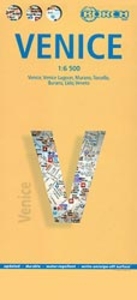
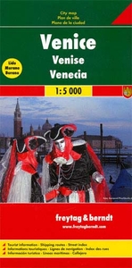
Venice Borch
Venice on a laminated and waterproof tourist map from Borch, combining a street plan of the city with plans of Murano, Burano, Torcello and the central part of the Lido, plus a road map of a large part of the mainland including Verona, Padua, Treviso, Mantua, etc.The main plan covers the city at 1:6, 500, prominently highlighting its numerous places of interest, including names of the main buildings along the Grand Canal. Locations of selected hotels are also shown. Vaporetto lines are marked and stations indicate line numbers. Coverage of the city does not extend to its west and east extremities – the map does cover the Biennale grounds but the parking facilities on Tronchetto are not included. An inset shows all the vaporetto lines across the city’s canals and the lagoon.
On the reverse is a map at 1:95.000 of the northern part of the lagoon showing the city’s road connection with the mainland, the islands, and the campsites around Punta Sabbioni. Street plans show Merano, Burano, the access from the vaporetto station to cathedral on Torcello, and the central part of the Lido. A road map of mainland at 1:900, 000 highlights the city’s road connections with Verona, Vicenza, Padua, Treviso, Udine and the Dolomites. All the plans and the maps are indexed, with lists of streets/localities, plus sights, public buildings, etc.
On the reverse is a map at 1:95.000 of the northern part of the lagoon showing the city’s road connection with the mainland, the islands, and the campsites around Punta Sabbioni. Street plans show Merano, Burano, the access from the vaporetto station to cathedral on Torcello, and the central part of the Lido. A road map of mainland at 1:900, 000 highlights the city’s road connections with Verona, Vicenza, Padua, Treviso, Udine and the Dolomites. All the plans and the maps are indexed, with lists of streets/localities, plus sights, public buildings, etc.

Product Description
Reviews/Comments
Add New
Intelligent Comparison
Archived Product
Florence Borch Stanfords
£8.99
Archived Product
Munich Borch Stanfords
£8.99
Archived Product
France Borch Stanfords
£9.99
Archived Product
Vienna Borch Stanfords
£8.99
Archived Product
Belize Borch Stanfords
£9.99
Archived Product

Venice Botteghe Stanfords
£16.99
Archived Product
Venice F&B Stanfords
£9.99
Archived Product
Phoenix Borch Stanfords
£8.99
Vouchers
No voucher codes found.
Do you know a voucher code for this product or supplier? Add it to Insights for others to use.
Do you know a voucher code for this product or supplier? Add it to Insights for others to use.
 Denmark