
 United Kingdom
 France
 Germany
 Netherlands
 Sweden
 USA
USA
 Italy
Italy
 Spain
Spain
More From Contributor


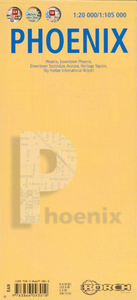
Phoenix Borch
Laminated waterproof, indexed plan of Phoenix at 1:105, 000 from Borch, with maps of downtown Phoenix, downtown Scottsdale, Arizona, Heritage Square, and Sky Harbor international airport. The main map shows the road network and most streets, with main roads named; rail and bus lines and stops are clearly marked. Points of interest such as museums, theaters, places of worship are shown; the map also includes 30 indexed ‘Top Sights’.The reverse includes a street plan of downtown Phoenix at 1:20, 000 with one-way streets marked, as well as bus lines and stops, with points of interest are prominently displayed; a street plan of downtown Scottsdale at 1:20, 000 has the same cartographic style. A small inset shows Heritage Square at 1:3, 000, with buildings such as the Arizona
Science Center easy to find. A map of Arizona at 1:3, 050, 000, shows the major road network, airports, and points of interests. All of these maps are indexed. A small inset of Sky Harbor International airport at 1:37, 500 shows road access, terminals, and parking lots, and nearby streets.There is also a small map of US administrative and time zones, as well as a small box detailing climate, population and statistical data on Phoenix.
Science Center easy to find. A map of Arizona at 1:3, 050, 000, shows the major road network, airports, and points of interests. All of these maps are indexed. A small inset of Sky Harbor International airport at 1:37, 500 shows road access, terminals, and parking lots, and nearby streets.There is also a small map of US administrative and time zones, as well as a small box detailing climate, population and statistical data on Phoenix.

Product Description
Reviews/Comments
Add New
Intelligent Comparison
Archived Product
Phoenix Noir Stanfords
£9.99
Archived Product
Athens Borch Stanfords
£8.99
Archived Product

Venice Borch Stanfords
£8.99
Archived Product

Phoenix Song Stanfords
£8.99
Archived Product

Phoenix Burning Stanfords
£6.99
Vouchers
No voucher codes found.
Do you know a voucher code for this product or supplier? Add it to Insights for others to use.
Do you know a voucher code for this product or supplier? Add it to Insights for others to use.
 Denmark