
 United Kingdom
 France
 Germany
 Netherlands
 Sweden
 USA
USA
 Italy
Italy
 Spain
Spain
More From Contributor


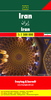


Iran Gizi Map
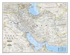
Iran on an indexed map at 1:2, 000, 000 from Gizi Map with bold altitude colouring to show its topography, provincial boundaries and an additional inset showing the administrative division into provinces, road and rail networks, places of interest, etc.Coverage extends west to include eastern Iraq with Baghdad, Kirkuk and Najaf, plus and whole of Kuwait. In the north and east much of Afghanistan and Turkmenistan are included. Most of the Persian Gulf is also covered, including the Strait of Hormuz. Topography is shown by bold altitude with plenty of names of various geographical features: mountain ranges, deserts, etc. Names of selected larger towns are shown in both Arabic and Latin alphabet.Road network is graded six types, plus selected country tracks, and shows driving
distances on main routes and locations of border crossings. Railway lines are included and domestic airports are marked. Also shown are internal administrative boundaries and names of the provinces.Symbols indicate various places of interest, including UNESCO World Heritage sites, archaeological sites, museums, etc. Latitude and longitude lines are drawn at 1° intervals. The index is on the reverse and lists location with names of the provinces. Multilingual legend includes English, Russian and Farsi. A separate inset at 1:8, 500, 000 showing Iran’s administrative division into provinces.* This title is also available as a wall map.
distances on main routes and locations of border crossings. Railway lines are included and domestic airports are marked. Also shown are internal administrative boundaries and names of the provinces.Symbols indicate various places of interest, including UNESCO World Heritage sites, archaeological sites, museums, etc. Latitude and longitude lines are drawn at 1° intervals. The index is on the reverse and lists location with names of the provinces. Multilingual legend includes English, Russian and Farsi. A separate inset at 1:8, 500, 000 showing Iran’s administrative division into provinces.* This title is also available as a wall map.

Product Description
Reviews/Comments
Add New
Intelligent Comparison
Archived Product

Iraq Gizi Map Stanfords
£9.99
Archived Product

Syria Gizi Map Stanfords
£9.99
Archived Product

Cuba Gizi Map Stanfords
£9.99
Archived Product

Mali Gizi Map Stanfords
£9.99
Archived Product

Mauritania Gizi Map Stanfords
£9.99
Archived Product

Kyrgyzstan Gizi Map Stanfords
£9.99
Archived Product

Pakistan Gizi Map Stanfords
£9.99
Archived Product

Oran IGN Map Stanfords
£11.99
Vouchers
No voucher codes found.
Do you know a voucher code for this product or supplier? Add it to Insights for others to use.
Do you know a voucher code for this product or supplier? Add it to Insights for others to use.
 Denmark