
 United Kingdom
 France
 Germany
 Netherlands
 Sweden
 USA
USA
 Italy
Italy
 Spain
Spain
More From Contributor


Iran Nelles
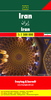
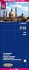
Iran at 1:1, 750, 000 from Nelles in the publisher’s new, light waterproof and tear-resistant format. The map is double-sided, with a good overlap between the sides. All place names are in the Latin alphabet only.Topography is shown by light, unobtrusive relief shading plus spot heights, with names of main mountain ranges and deserts. Road network shows driving distances on main and selected secondary routes and indicates border crossings. Railway lines are included and local airports are marked. Also shown are boundaries and names of Iran’s administrative provinces. Symbols highlight various places of interest, including natural parks, UNESCO World Heritage sites, etc. The map has latitude and longitude lines at 1º intervals and is not indexed. Map legend includes English.

Product Description
Reviews/Comments
Add New
Vouchers
No voucher codes found.
Do you know a voucher code for this product or supplier? Add it to Insights for others to use.
Do you know a voucher code for this product or supplier? Add it to Insights for others to use.
 Denmark