
 United Kingdom
 France
 Germany
 Netherlands
 Sweden
 USA
USA
 Italy
Italy
 Spain
Spain
More From Contributor


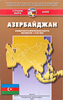


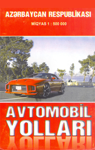
Azerbaidjan
Azerbaijan at 1:500, 000 from the locally based Baki Kartoqrafiya Fabriki on a contoured map showing the country’s road and rail networks, oil and gas pipelines, internal administrative divisions, etc.Topography is shown by contours at 100m intervals with additional relief shading and spot heights. Colouring and/or graphics indicate deserts, swamps and marshland, different types of forests, etc. Coastal waters have bathymetric contours and show locations of oil/gas rigs.Road network includes local roads, gives driving distances on main routes and indicates border crossings. On roads across mountain passes altitude and opening months are marked. Railway lines are shown with stations and coastal ferry routes are included. Also marked are oil and gas pipelined. Latitude and longitude
lines are drawn at 20’ and 30’ respectively.Map legend is in Azeri only.
lines are drawn at 20’ and 30’ respectively.Map legend is in Azeri only.

Product Description
Reviews/Comments
Add New
Vouchers
No voucher codes found.
Do you know a voucher code for this product or supplier? Add it to Insights for others to use.
Do you know a voucher code for this product or supplier? Add it to Insights for others to use.
 Denmark