
 United Kingdom
 France
 Germany
 Netherlands
 Sweden
 USA
USA
 Italy
Italy
 Spain
Spain
More From Contributor


Azangaro
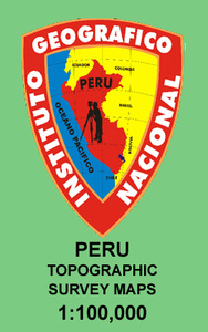
One of the maps in the topographic survey of Peru from the country’s national survey organization, Instituto Geográfico Nacional. Contours are at 25m intervals and colouring/symbols indicate different types of terrain and vegetation. Some of the maps may contain small blank spaces representing as yet unmapped areas. Each sheet covers 30’ latitude by 30’ longitude. The maps have a 1km UTM grid and margin ticks for latitude and longitude at intervals of 1’. Publication dates vary; most maps were published in 1960s to 1990s, with some sheets revised more recently. Map legend is in Spanish only, except in the more recent editions which also include English.

Product Description
Reviews/Comments
Add New
Vouchers
No voucher codes found.
Do you know a voucher code for this product or supplier? Add it to Insights for others to use.
Do you know a voucher code for this product or supplier? Add it to Insights for others to use.
 Denmark