More From Contributor

£35.00
Cambridgeshire Pevsner Architectural Guide, in a series of publications begun with the express aim of providing up-to-date guides to the most significant buildings in every part of the country, suitable for both general reader & specialist. Each volume provides an introductory overview of the architecture of the area, followed by a descriptive gazetteer arranged alphabetically by place. Whilst cathedrals & their furnishings, great country houses & their parks form the grand set pieces, the books demonstrate the enjoyable diversity of architecture in the British Isles in accounts of rural churches & farmsteads, Victorian public buildings & industrial monuments. A continuing programme of publication keeps the series up-to-date with new information on older buildings & recent architecture while maintaining the tradition of Pevsner`s own succinct accounts. Each book has over 100 photographs, mostly specially commissioned, numerous maps & plans, a glossary & indexes. ...
Archived Product
£5.99
Ayrshire, Lanark & the Isle of Arran Cycle Map at 1:110, 000 from Sustrans, including Lochs & Glens South route, Ayshire Coast Cycleway, Cunninghame Cycleway, plus three day rides: Neilston Circuit, Larkhall Loop, & Robert Burn Ride. Street plans show Ayr, Hamilton, Irvine, Kilmarnock, Kilwinning & Paisley. Maps is this Sustrans series show all the National & Regional Cycle Network routes clearly numbered & have the colouring distinguishing between the on-road & traffic-free sections. The publishers’ own recommendations are shown in contrasting colour &, in most titles, are in addition presented on the reverse side on separate panels where each circuit is annotated with useful notes. The maps have contours & altitude colouring to show the topography, with additional gradient markings. Towns along the routes are annotated with symbols indicating what facilities can be found there. Also marked are various places of interest, on or near the routes, & railway lines are shown with stations for access to the routes by rail. On the reverse each title also provides large, clear city centre street plans of main towns, highlighting the Cycle Network and/or the recommended routes. Also included are contact details of tourist information centres. To see the list of titles in this series please click on the series link. ...
Archived Product
£9.50
Topographical survey of Belgium at 1:20, 000 from Nationaal Geografisch Instituut / Institut Géographique National, the country’s national survey organization. Each 20K map covers one quarter of the corresponding 1:50, 000 map (with adjustments in the border & coastal areas). The maps provide all the information expected of topographic mapping at this scale & in addition have an unusually large amount of vegetation and/or land use information (different types of woodlands, gardens, orchards, heath, etc). The maps have a 1-km UTM grid, with margin ticks for latitude & longitude at intervals of 1`. Map legend & a glossary of terms used on the maps include English. Stanfords keeps as regular stock 20K maps for the World War I battlefields around the Ypres, Messines & Passchendaele, & for the area of the Battle of Waterloo. The 1:20, 000 survey covers the whole of Belgium & maps for other regions can be supplied as special orders. To see the list of titles in this series please click on the series link.PLEASE NOTE: the Long-Distance Footpaths Map of Belgium at 1:300, 000 which shows the division of Belgium into the 50K survey sheets can also be used to see in more detail coverage by the 20K maps. ...
Archived Product
£11.99
Ardennes Recreational Maps at a scale of 1:25, 000 enable you to discover the Ardennes from junction to junction, each associated with a locality, through a network of hiking, cycling or riding paths. The network of mini walks consists of suggested routes with kilometre distance marked showing field boundaries & urbanised built up areas. Contour markings are at five metre intervals. The map legend is in English, French, Dutch & German. You can scan QR codes on the map for details about the respective locality or upload GPX files of the proposed routes via the provided website. ...
Archived Product
£149.00
The much anticipated Sky-Watcher AZ4 Alt-Azimuth mount is set to be a hit with astronomers & terrestrial observers alike. The design features separate clutches on both the Altitude & Azimuth axes & a panning arm, which can be fixed in two separate positions. The movements are buttery-smooth & telescopes can be manipulated with effortless precision. Telescope OTA’s attach to the mount via a standard Sky-Watcher dovetail bar. Also supplied with this mount is an L-bracket which allows the easy attachment of a spotting scope or camera. Supplied with lightweight aluminium legs for optimum portability, Maximum recommended payload: Sky-Watcher D150/F1200 Reflector (Explorer-150PL) ...
Archived Product
£159.00
Ideal No Fuss, Grab-&-Go Telescope Mount for Easy Visual Astronomy as well as Daytime Terrestrial Observations!! The AZ5 Deluxe Alt-Azimuth Mount Head can be fitted to any tripod via a standard 3/8” screw connector. Constructed from cast aluminium & designed to attach small telescopes up to 5kg in weight, fitted with a 45mm dovetail bar, or other equipment by using the optional L-bracket (available separately). Supplied with two flexible slow-motion cables, one for vertical & one for horizontal smooth fine motion control. The mount can also be moved manually around each axis, for rapid panning & elevation adjustments. ...
Archived Product
£12.99
In a big Arabian city, an orphan boy is forced to work as a camel jockey
- a dangerous job he doesn`t like. But a new friendship
...
Archived Product
£29.95
One of the maps in the topographic survey of Peru from the country’s national survey organization, Instituto Geográfico Nacional. Contours are at 25m intervals & colouring/symbols indicate different types of terrain & vegetation. Some of the maps may contain small blank spaces representing as yet unmapped areas. Each sheet covers 30’ latitude by 30’ longitude. The maps have a 1km UTM grid & margin ticks for latitude & longitude at intervals of 1’. Publication dates vary; most maps were published in 1960s to 1990s, with some sheets revised more recently. Map legend is in Spanish only, except in the more recent editions which also include English. ...
Archived Product
£24.95
Azarbayejan-e-Gharbi Province & Orumiyah City on a double-sided map from the Gitashenasi Institute with dual script names, English legend & tourist information. On one side is a road map of the province at 1:680, 000, showing road & rails networks, & annotated with symbols making locations of petrol stations, tourist accommodation, & various places of interest. Names of main towns are in both Arabic & Roman alphabets, smaller locations & other information such a peak heights are in Arabic only. Also included is a distance table & notes about the province: brief in English & longer in Farsi. On the reverse is a street plan of Orumiyeh City at 1:19.600, annotated with symbols highlighting various facilities & places of interest, Names of main streets & districts are in both scripts. The plan has no index, but

Includes::
a list of hotels, plus notes in Farsi only. Map legends for both sides include English.

...
Archived Product
£9.99
Set in the 5th century AD, Azazeel is the exquisitely crafted tale of a Coptic monk`s journey from Upper Egypt to Alexandria & then Syria during a time of massive upheaval in the early Church. Winner of the Arab Booker Prize, Azazeel highlights how the history of our civilization has been warped by greed & avarice since its very beginnings & how one man`s beliefs are challenged not only by the malice of the devil, but by the corruption with the early Church. In sparse & often sparkling prose that reflects the arid beauty of the Syrian landscape, Azazeel is a novel that forces us to re-think many of our long-held beliefs & invites us to rediscover a lost history. ...
Archived Product

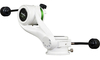
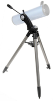
AZ4-2 Alt-Azimuth Mount (with 1.75” Stainles Steel Tripod And
Spotting Scope Bracket)

The much anticipated Sky-Watcher AZ4 Alt-Azimuth mount is set to be a hit with astronomers and terrestrial observers alike. The design features separate clutches on both the Altitude and Azimuth axes and a panning arm, which can be fixed in two separate positions. The movements are buttery-smooth and telescopes can be manipulated with effortless precision. Telescope OTA’s attach to the mount via a standard Sky-Watcher dovetail bar. Also supplied with this mount is an L-bracket which allows the easy attachment of a spotting scope or camera. Supplied with 1.75” stainless steel legs for maximum strength and stability. Maximum recommended payload: Sky-Watcher D150/F1200 Reflector (Explorer-150PL)
RIP - This product is no longer available on our network. It was last seen on 25.09.2019

This page now acts as a permanent archive for this product. Add more information using the comments box below to ensure it can still be found by future generations.

Use our search facility to see if it is available from an alternative contributor.
  • Availability: Out Of Stock
  • Supplier: Stanfords
  • SKU: 6930096630291
Availability: In Stock
£199.00

Product Description

The much anticipated Sky-Watcher AZ4 Alt-Azimuth mount is set to be a hit with astronomers & terrestrial observers alike. The design features separate clutches on both the Altitude & Azimuth axes & a panning arm, which can be fixed in two separate positions. The movements are buttery-smooth & telescopes can be manipulated with effortless precision. Telescope OTA’s attach to the mount via a standard Sky-Watcher dovetail bar. Also supplied with this mount is an L-bracket which allows the easy attachment of a spotting scope or camera. Supplied with 1.75” stainless steel legs for maximum strength & stability. Maximum recommended payload: Sky-Watcher D150/F1200 Reflector (Explorer-150PL)

Reviews/Comments

Add New

Intelligent Comparison

Oooops!
We couldn't find anything!
Perhaps this product's unique.... Or perhaps we are still looking for comparisons!
Click to bump this page and we'll hurry up.

Price History

Vouchers

No voucher codes found.
Do you know a voucher code for this product or supplier? Add it to Insights for others to use.

Facebook

Jargon Buster

Stainless steel - A stain and corrosion resistant steel blend
Steel - An alloy made predominately of Iron combined with <2% carbon
Camera - An electronic device used for taking photographs
Tripod - A three legged device for supporting an object - commonly a camera.
Set - a group of items usually related to one another. Some objects cannot function without the complete set of items.
Altitude - Something that can be quite high in relation to sea or ground level.
Design - A drawing or styles that shows the look and functionality of something before its made.
Anticipated - Something, such as an event that is expected or probable.

Supplier Information

Stanfords
Stanfords was established in 1853 and opened their iconic Covent Garden flagship store in 1901. They have become the top retailer of maps, travel books and accessories in the UK and arguably offer the largest selection of maps and travel books worldwide. Famous names such as Captain Robert Falcon Scott, Ranulph Fiennes and Michael Palin have purchased from Stanfords. They now have a shop in Bristol and both stores together with other venues operate a calendar of events including talks, book signings and exhibitions. As a specialist map retailer, the map selection is comprehensive and includes road maps, street maps and walking maps from worldwide destinations, as well as a selection of world atlases and wall maps. Books include travel guides and travel literature. Stanfords also stock globes, from miniatures made of blue marble to magnificent floor-standing globes. The website features a selection of interesting articles on travel topics.
Page Updated: 2023-11-12 20:15:36

Community Generated Product Tags

Oh No! The productWIKI community hasn't generated any tags for this product yet!
Menu