More From Contributor
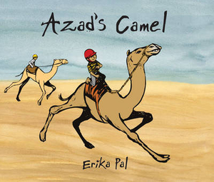
£9.50
Topographical survey of Belgium at 1:20, 000 from Nationaal Geografisch Instituut / Institut Géographique National, the country’s national survey organization. Each 20K map covers one quarter of the corresponding 1:50, 000 map (with adjustments in the border & coastal areas). The maps provide all the information expected of topographic mapping at this scale & in addition have an unusually large amount of vegetation and/or land use information (different types of woodlands, gardens, orchards, heath, etc). The maps have a 1-km UTM grid, with margin ticks for latitude & longitude at intervals of 1`. Map legend & a glossary of terms used on the maps include English. Stanfords keeps as regular stock 20K maps for the World War I battlefields around the Ypres, Messines & Passchendaele, & for the area of the Battle of Waterloo. The 1:20, 000 survey covers the whole of Belgium & maps for other regions can be supplied as special orders. To see the list of titles in this series please click on the series link.PLEASE NOTE: the Long-Distance Footpaths Map of Belgium at 1:300, 000 which shows the division of Belgium into the 50K survey sheets can also be used to see in more detail coverage by the 20K maps. ...
Archived Product
£11.99
Ardennes Recreational Maps at a scale of 1:25, 000 enable you to discover the Ardennes from junction to junction, each associated with a locality, through a network of hiking, cycling or riding paths. The network of mini walks consists of suggested routes with kilometre distance marked showing field boundaries & urbanised built up areas. Contour markings are at five metre intervals. The map legend is in English, French, Dutch & German. You can scan QR codes on the map for details about the respective locality or upload GPX files of the proposed routes via the provided website. ...
Archived Product
£149.00
The much anticipated Sky-Watcher AZ4 Alt-Azimuth mount is set to be a hit with astronomers & terrestrial observers alike. The design features separate clutches on both the Altitude & Azimuth axes & a panning arm, which can be fixed in two separate positions. The movements are buttery-smooth & telescopes can be manipulated with effortless precision. Telescope OTA’s attach to the mount via a standard Sky-Watcher dovetail bar. Also supplied with this mount is an L-bracket which allows the easy attachment of a spotting scope or camera. Supplied with lightweight aluminium legs for optimum portability, Maximum recommended payload: Sky-Watcher D150/F1200 Reflector (Explorer-150PL) ...
Archived Product
£199.00
The much anticipated Sky-Watcher AZ4 Alt-Azimuth mount is set to be a hit with astronomers & terrestrial observers alike. The design features separate clutches on both the Altitude & Azimuth axes & a panning arm, which can be fixed in two separate positions. The movements are buttery-smooth & telescopes can be manipulated with effortless precision. Telescope OTA’s attach to the mount via a standard Sky-Watcher dovetail bar. Also supplied with this mount is an L-bracket which allows the easy attachment of a spotting scope or camera. Supplied with 1.75” stainless steel legs for maximum strength & stability. Maximum recommended payload: Sky-Watcher D150/F1200 Reflector (Explorer-150PL) ...
Archived Product
£159.00
Ideal No Fuss, Grab-&-Go Telescope Mount for Easy Visual Astronomy as well as Daytime Terrestrial Observations!! The AZ5 Deluxe Alt-Azimuth Mount Head can be fitted to any tripod via a standard 3/8” screw connector. Constructed from cast aluminium & designed to attach small telescopes up to 5kg in weight, fitted with a 45mm dovetail bar, or other equipment by using the optional L-bracket (available separately). Supplied with two flexible slow-motion cables, one for vertical & one for horizontal smooth fine motion control. The mount can also be moved manually around each axis, for rapid panning & elevation adjustments. ...
Archived Product
£29.95
One of the maps in the topographic survey of Peru from the country’s national survey organization, Instituto Geográfico Nacional. Contours are at 25m intervals & colouring/symbols indicate different types of terrain & vegetation. Some of the maps may contain small blank spaces representing as yet unmapped areas. Each sheet covers 30’ latitude by 30’ longitude. The maps have a 1km UTM grid & margin ticks for latitude & longitude at intervals of 1’. Publication dates vary; most maps were published in 1960s to 1990s, with some sheets revised more recently. Map legend is in Spanish only, except in the more recent editions which also include English. ...
Archived Product
£24.95
Azarbayejan-e-Gharbi Province & Orumiyah City on a double-sided map from the Gitashenasi Institute with dual script names, English legend & tourist information. On one side is a road map of the province at 1:680, 000, showing road & rails networks, & annotated with symbols making locations of petrol stations, tourist accommodation, & various places of interest. Names of main towns are in both Arabic & Roman alphabets, smaller locations & other information such a peak heights are in Arabic only. Also included is a distance table & notes about the province: brief in English & longer in Farsi. On the reverse is a street plan of Orumiyeh City at 1:19.600, annotated with symbols highlighting various facilities & places of interest, Names of main streets & districts are in both scripts. The plan has no index, but

Includes::
a list of hotels, plus notes in Farsi only. Map legends for both sides include English.

...
Archived Product
£9.99
Set in the 5th century AD, Azazeel is the exquisitely crafted tale of a Coptic monk`s journey from Upper Egypt to Alexandria & then Syria during a time of massive upheaval in the early Church. Winner of the Arab Booker Prize, Azazeel highlights how the history of our civilization has been warped by greed & avarice since its very beginnings & how one man`s beliefs are challenged not only by the malice of the devil, but by the corruption with the early Church. In sparse & often sparkling prose that reflects the arid beauty of the Syrian landscape, Azazeel is a novel that forces us to re-think many of our long-held beliefs & invites us to rediscover a lost history. ...
Archived Product
£11.95
Attractive map of the country, showing physical relief & communication information
- roads, railways, canals. Intermediate driving
...
Archived Product
£22.95
Azerbaijan at 1:500, 000 from the locally based Baki Kartoqrafiya Fabriki on a contoured map showing the country’s road & rail networks, oil & gas pipelines, internal administrative divisions, etc. Topography is shown by contours at 100m intervals with additional relief shading & spot heights. Colouring and/or graphics indicate deserts, swamps & marshl&, different types of forests, etc. Coastal waters have bathymetric contours & show locations of oil/gas rigs. Road network

Includes::
local roads, gives driving distances on main routes & indicates border crossings. On roads across mountain passes altitude & opening months are marked. Railway lines are shown with stations & coastal ferry routes are included. Also marked are oil & gas pipelined. Latitude & longitude lines are drawn at 20’ & 30’ respectively. Map legend is in Azeri only.

...
Archived Product

Azad`s Camel

In a big Arabian city, an orphan boy is forced to work as a camel jockey - a dangerous job he doesn`t like. But a new friendship and a magical escape into the desert are about to change his life...Camel racing is a popular sport in the Gulf states. Child jockeys are used to ride the camels and come from Pakistan, Bangladesh, Sudan, Mauritania and Eritrea. Often poor families are persuaded to sell sons as young as five years old, who are taken away to be trained and often badly treated. Qatar, Oman and the United Arab Emirates have banned the use of child jockeys and are returning the children to their families so that they can live a normal life. Robots are now being used in place of jockeys in the United Arab Emirates, but in some Middle Eastern countries small children are still
being forced to race camels. ”The pictures are beautiful - really evocative.” Elizabeth Laird, prize-winning author of Crusade, The Garbage King and Lost Riders (also about a camel jockey)
RIP - This product is no longer available on our network. It was last seen on 25.09.2019

This page now acts as a permanent archive for this product. Add more information using the comments box below to ensure it can still be found by future generations.

Use our search facility to see if it is available from an alternative contributor.
  • Availability: Out Of Stock
  • Supplier: Stanfords
  • SKU: 9781845079826
Availability: In Stock
£12.99

Product Description

In a big Arabian city, an orphan boy is forced to work as a camel jockey
- a dangerous job he doesn`t like. But a new friendship & a magical escape into the desert are about to change his life... Camel racing is a popular sport in the Gulf states. Child jockeys are used to ride the camels & come from Pakistan, Bangladesh, Sudan, Mauritania & Eritrea. Often poor families are persuaded to sell sons as young as five years old, who are taken away to be trained & often badly treated. Qatar, Oman & the United Arab Emirates have banned the use of child jockeys & are returning the children to their families so that they can live a normal life. Robots are now being used in place of jockeys in the United Arab Emirates, but in some Middle Eastern countries small children are still being forced to race camels. ” The pictures are beautiful
- really evocative.” Elizabeth Laird, prize-winning author of Crusade, The Garbage King & Lost Riders (also about a camel jockey)

Reviews/Comments

Add New

Intelligent Comparison

Oooops!
We couldn't find anything!
Perhaps this product's unique.... Or perhaps we are still looking for comparisons!
Click to bump this page and we'll hurry up.

Price History

Vouchers

No voucher codes found.
Do you know a voucher code for this product or supplier? Add it to Insights for others to use.

Facebook

Jargon Buster

King - The figure head of a monarch
Small - something that takes up less space than normal.
Normal - often relating to someone or something that is average.
Popular - Something that is admired and liked by many people.
Children - A young life form within the early stages of physical development,

Supplier Information

Stanfords
Stanfords was established in 1853 and opened their iconic Covent Garden flagship store in 1901. They have become the top retailer of maps, travel books and accessories in the UK and arguably offer the largest selection of maps and travel books worldwide. Famous names such as Captain Robert Falcon Scott, Ranulph Fiennes and Michael Palin have purchased from Stanfords. They now have a shop in Bristol and both stores together with other venues operate a calendar of events including talks, book signings and exhibitions. As a specialist map retailer, the map selection is comprehensive and includes road maps, street maps and walking maps from worldwide destinations, as well as a selection of world atlases and wall maps. Books include travel guides and travel literature. Stanfords also stock globes, from miniatures made of blue marble to magnificent floor-standing globes. The website features a selection of interesting articles on travel topics.
Page Updated: 2023-11-12 20:15:36

Community Generated Product Tags

Oh No! The productWIKI community hasn't generated any tags for this product yet!
Menu