
 United Kingdom
 France
 Germany
 Netherlands
 Sweden
 USA
USA
 Italy
Italy
 Spain
Spain
More From Contributor


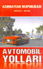


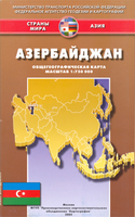
Azerbaidjan
Attractive map of the country, showing physical relief and communication information - roads, railways, canals. Intermediate driving didtsances on roads are marked. General relief is shown through hill shading and elevation tinting. Other detail: national parks, administrative boundaries, irrigation channels, oil wells, seasonal rivers, mountain peaks, bathymetric tinting, names of mountain ranges. Latitude and longitude lines are at 30` intervals. Also included is a street plan of Baku and an index booklet for the country map, which also presents some background information.All text is in cyrillic only.

Product Description
Reviews/Comments
Add New
Intelligent Comparison
Archived Product
Azerbaidjan Stanfords
£22.95
Vouchers
No voucher codes found.
Do you know a voucher code for this product or supplier? Add it to Insights for others to use.
Do you know a voucher code for this product or supplier? Add it to Insights for others to use.
 Denmark