
 United Kingdom
 France
 Germany
 Netherlands
 Sweden
 USA
USA
 Italy
Italy
 Spain
Spain
More From Contributor


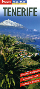
Tenerife Flexi Map
Tenerife on a laminated, tear-resistant Insight Flexi Map, with a road map of the island, street plans of central Santa Cruz de Tenerife and Puerto de la Cruz, all indexed and highlighting numerous places of interest, plus extensive tourist information. On one side is a road map of Tenerife at 1:170, 000, with La Gomera as an inset at the same scale. Topography is shown by relief shading, with spot heights for main peaks. National parks are highlighted. The maps present the islands’ road networks, including selected local roads and country tracks, with driving distance shown on main routes. Interesting town and villages are highlighted and symbols mark other sights, beaches, etc. The maps have no geographical coordinates. The index lists places and points of interest.On the
reverse are street plans of central Santa Cruz de Tenerife and Puerto de la Cruz, both at 1:12, 500. Public buildings, places of interest and selected hotels are prominently highlighted. Both plans are indexed, including separate lists of various sights. Also included is an overview map of the Canary Islands showing ferry connections.A special feature of the Insight Flexi series are panels with additional tourist information:- 30 main sights, neatly grouped into sections covering Major Attractions, Shopping and Eating Out, Beaches, Dramatic Landscapes, plus Other Place of Interest, are given brief descriptions and are prominently highlighted on the relevant maps.- Further panels provide information on Getting Around and Facts for Visitors, including tourist information offices,
public holidays, opening times, money, telecommunication and monthly climate charts.To see other titles in this series please click on the series link.

Product Description
Reviews/Comments
Add New
Intelligent Comparison
Archived Product
Venice Flexi Map Stanfords
£4.99
Archived Product
Taipei Flexi Map Stanfords
£4.99
Archived Product
Jersey Flexi Map Stanfords
£4.99
Archived Product
Perth Flexi Map Stanfords
£4.99
Archived Product
Paris Flexi Map Stanfords
£4.99
Archived Product
Crete Flexi Map Stanfords
£4.99
Archived Product
Hanoi Flexi Map Stanfords
£4.99
Archived Product
Guernsey Flexi Map Stanfords
£4.99
Vouchers
No voucher codes found.
Do you know a voucher code for this product or supplier? Add it to Insights for others to use.
Do you know a voucher code for this product or supplier? Add it to Insights for others to use.
 Denmark