
 United Kingdom
 France
 Germany
 Netherlands
 Sweden
 USA
USA
 Italy
Italy
 Spain
Spain
More From Contributor


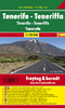
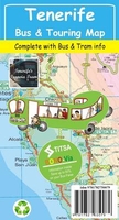
Tenerife Bus & Touring Map
Tenerife at 1:100, 000 on a road map from Discovery Walking Guides with a vivid presentation of the island’s topography and roads annotated with bus numbers, plus on the reverse street plans of main towns and holiday resorts and a timetable of TITSA’s bus service. Current edition was published in January 2015.On one side is a map of the island with bright altitude colouring showing its mountainous interior. Roads are annotated with numbers of of local bus services. Symbols indicate locations of petrol stations, car parks, picnic areas, viewpoints, campsites, etc. The map has a 5km UTM grid and is indexed.On the reverse are detailed street plans of central Sana Cruz de Tenerife, Puetro de la Cruz (with index of hotels and apartments), Los Gigantes – Puerto de Santiago –
Playa de la Arena, Playa de las Americas – Los Cristianos (with index of place names), Las Galletas – Ten Bel – Costa del Silencio, plus the Golf del Sur – Amarilla Golf area. Also provided are timetables for TITSA’s bus services, highlighting services recommended for sightseeing, plus a distance table.
Playa de la Arena, Playa de las Americas – Los Cristianos (with index of place names), Las Galletas – Ten Bel – Costa del Silencio, plus the Golf del Sur – Amarilla Golf area. Also provided are timetables for TITSA’s bus services, highlighting services recommended for sightseeing, plus a distance table.

Product Description
Reviews/Comments
Add New
Vouchers
No voucher codes found.
Do you know a voucher code for this product or supplier? Add it to Insights for others to use.
Do you know a voucher code for this product or supplier? Add it to Insights for others to use.
 Denmark