
 United Kingdom
 France
 Germany
 Netherlands
 Sweden
 USA
USA
 Italy
Italy
 Spain
Spain
More From Contributor


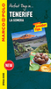


Tenerife And La Gomera
Tenerife at 1:140, 000 and La Gomera at 1:100, 000 on a waterproof and tear-resistant map with street plans of central Santa Cruz, Puetro de la Cruz and the Los-Cristianos - Playa de las Americas - Playa Adeje - Torviscas area, all indexed.The two islands have relief shading to show their topography, with heights of numerous peaks and names of valleys and other geographical features. National parks are highlighted. Road network includes minor local roads and tracks, gives driving distances on main routes, and highlights scenic roads. Main footpaths are also marked.14 best sights on Tenerife are prominently marked and annotated with brief descriptions, with symbols indicating other places of interest on both islands, including campsites, beaches, marinas, snorkeling and deep sea
fishing sites, etc. The maps are indexed, with separate lists places of interest and beaches. No geographical coordinates are marked. Large clear street plans, also indexed for sights, hotels, shopping, etc., cover Santa Cruz de Tenerife, Puetro de la Cruz and the Los-Cristianos - Playa de las Americas - Playa Adeje - Torviscas area. Also provided is a map showing the whole of the Canaries group with ferry routes, climate charts and other useful tourist information.PLEASE NOTE( (22.9.2011): following the changes during 2011 in the road numbering on La Gomera from TF to GM numbers, this title does not yet show TF711 and TF713 as GM1 and GM2 respectively. Other roads, due to be re-numbered during 2011, are not numbered on the map.
fishing sites, etc. The maps are indexed, with separate lists places of interest and beaches. No geographical coordinates are marked. Large clear street plans, also indexed for sights, hotels, shopping, etc., cover Santa Cruz de Tenerife, Puetro de la Cruz and the Los-Cristianos - Playa de las Americas - Playa Adeje - Torviscas area. Also provided is a map showing the whole of the Canaries group with ferry routes, climate charts and other useful tourist information.PLEASE NOTE( (22.9.2011): following the changes during 2011 in the road numbering on La Gomera from TF to GM numbers, this title does not yet show TF711 and TF713 as GM1 and GM2 respectively. Other roads, due to be re-numbered during 2011, are not numbered on the map.
Product Description
Reviews/Comments
Add New
Intelligent Comparison
Archived Product
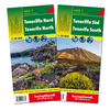
Southern Tenerife & La Gomera Stanfords
£12.99
Archived Product
Southern Tenerife & La Gomera Stanfords
£12.99
Vouchers
No voucher codes found.
Do you know a voucher code for this product or supplier? Add it to Insights for others to use.
Do you know a voucher code for this product or supplier? Add it to Insights for others to use.
 Denmark