
 United Kingdom
 France
 Germany
 Netherlands
 Sweden
 USA
USA
 Italy
Italy
 Spain
Spain
More From Contributor


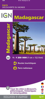
Madagascar
Madagascar on a large, double-sided, indexed road map with tourist information, a plan of central Antananarivo and an inset showing the Comoros Islands. National parks and other protected areas are highlighted on a base map with topography shown by bold relief shading with spot heights. Road network includes seasonal tracks and shows locations of petrol stations and driving distances on main routes. Railways, local airports and ferry routes are marked and the map shows the country
Product Description
Reviews/Comments
Add New
Intelligent Comparison
Archived Product
Madagascar Stanfords
£9.95
Archived Product
Madagascar Stanfords
£4.99
Archived Product

Madagascar Stanfords
£10.95
Archived Product
Madagascar Stanfords
£9.50
Archived Product
Madagascar Stanfords
£8.50
Archived Product

Madagascar Stanfords
£17.99
Archived Product

Madagascar F&B Stanfords
£10.99
Archived Product
Madagascar IGN Stanfords
£10.99
Vouchers
No voucher codes found.
Do you know a voucher code for this product or supplier? Add it to Insights for others to use.
Do you know a voucher code for this product or supplier? Add it to Insights for others to use.
 Denmark