
 United Kingdom
 France
 Germany
 Netherlands
 Sweden
 USA
USA
 Italy
Italy
 Spain
Spain
More From Contributor


Madagascar F&B
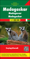
Madagascar at 1:1, 000, 000 on a large, double-sided, indexed road map from Freytag & Berndt, with tourist information and insets showing Mauritius and Reunion islands. National parks and other protected areas are prominently highlighted on a base map with topography shown by bold relief shading with spot heights. The map divides Madagascar north/south with Antananarivo included on both sides. Road network includes country tracks, shows locations of petrol stations, and gives driving distances on main routes. Railways, local airports and ferry routes are marked and the map shows Madagascar’s internal administrative boundaries with names of districts. Icons highlight locations with hotels and campsites, beaches, diving and windsurfing sites, various places of interest including
UNESCO World Heritage sites, spas, wells, caves, etc. The map has latitude and longitude lines at intervals of 1° and is indexed.. Multilingual map legend includes English. An inset at the same scale of 1:1, 000, 000 shows Mauritius, Reunion and Rodrigues islands,
UNESCO World Heritage sites, spas, wells, caves, etc. The map has latitude and longitude lines at intervals of 1° and is indexed.. Multilingual map legend includes English. An inset at the same scale of 1:1, 000, 000 shows Mauritius, Reunion and Rodrigues islands,

Product Description
Reviews/Comments
Add New
Vouchers
No voucher codes found.
Do you know a voucher code for this product or supplier? Add it to Insights for others to use.
Do you know a voucher code for this product or supplier? Add it to Insights for others to use.
 Denmark