
 United Kingdom
 France
 Germany
 Netherlands
 Sweden
 USA
USA
 Italy
Italy
 Spain
Spain
More From Contributor
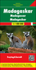

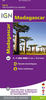


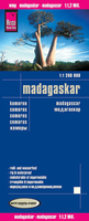
Madagascar Reise Know-How
Madagascar at 1:1, 200, 000 on an indexed, waterproof and tear-resistant road map with topographic and tourist information, published by Reise Know-How as part of their highly acclaimed World Mapping Project. The map is double-sided to provide the best balance between a good scale and a convenient size sheet, with a generous overlap and Antananarivo included on both sides. Coverage includes the Comoros Islands and Mayotte.Topography is indicated by altitude colouring with spot heights and mountain passes, names of mountain ranges and plateaux, seasonal rivers and lakes, mangroves and coral reefs. Road information includes seasonal tracks and indicates intermediate driving distances on main and secondary roads and locations of petrol stations. Railways, local airfields and coastal
ferry connections are also shown, as well as internal administrative boundaries. National parks and protected areas are marked and symbols highlight various places of interest: selected accommodation including campsites, UNESCO world heritage sites, rovas (former royal palaces), beaches, surfing and diving locations, viewpoints, wells, medical facilities, etc. The map has a latitude/longitude grid at intervals of 1º and an index of localities with a separate list of national parks and reserves. Map legend includes English.
ferry connections are also shown, as well as internal administrative boundaries. National parks and protected areas are marked and symbols highlight various places of interest: selected accommodation including campsites, UNESCO world heritage sites, rovas (former royal palaces), beaches, surfing and diving locations, viewpoints, wells, medical facilities, etc. The map has a latitude/longitude grid at intervals of 1º and an index of localities with a separate list of national parks and reserves. Map legend includes English.

Product Description
Reviews/Comments
Add New
Vouchers
No voucher codes found.
Do you know a voucher code for this product or supplier? Add it to Insights for others to use.
Do you know a voucher code for this product or supplier? Add it to Insights for others to use.
 Denmark