
 United Kingdom
 France
 Germany
 Netherlands
 Sweden
 USA
USA
 Italy
Italy
 Spain
Spain
More From Contributor

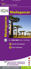


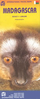
Madagascar ITMB
Madagascar at 1: 1, 000, 000 on an indexed, double-sided map from ITMB with a large, clear street plan of central Antananarivo. The maps divides the island north/south with a small overlap between the sides. Topography is presented by bold altitude colouring and spot heights, both in feet. Graphic indicate swamp, wetland and mangrove areas and salt pans. National parks and other protected areas are highlighted.The map shows the country’s road network, indicating paved and unsurfaced secondary roads, plus selected tracks. Driving distances are shown on main routes and locations of petrol supplies are marked. Also shown are railway connections, domestic airports and aerodromes/landing fields, and internal administrative boundaries with names of the provinces. Symbols indicate
various places of interest, including locations with tourist accommodation, campsites, beaches and surfing sites, historical and archaeological sites, etc. Latitude and longitude lines are drawn at 2° intervals. Each side has a separate index.Coverage includes Comoros Islands and Mayotte with ferry routes between the islands and to Madagascar. Also provided is a large, clear street plan of central Antananarivo indicating main places of interest, hotels, various facilities, etc.
various places of interest, including locations with tourist accommodation, campsites, beaches and surfing sites, historical and archaeological sites, etc. Latitude and longitude lines are drawn at 2° intervals. Each side has a separate index.Coverage includes Comoros Islands and Mayotte with ferry routes between the islands and to Madagascar. Also provided is a large, clear street plan of central Antananarivo indicating main places of interest, hotels, various facilities, etc.

Product Description
Reviews/Comments
Add New
Vouchers
No voucher codes found.
Do you know a voucher code for this product or supplier? Add it to Insights for others to use.
Do you know a voucher code for this product or supplier? Add it to Insights for others to use.
 Denmark