
 United Kingdom
 France
 Germany
 Netherlands
 Sweden
 USA
USA
 Italy
Italy
 Spain
Spain
More From Contributor


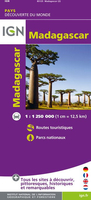
Madagascar IGN
Madagascar at 1:1, 250, 000 from the IGN with cartography from MairDumont, with more smaller settlements than on other maps of the whole country. Very effective relief shading, altitude colouring and spot heights present the topography, with colouring and/or graphics for seasonal lakes and swamps, mangrove, sand dunes, rice fields, waterfalls, etc. National parks and other protected areas are highlighted.The map indicates unpaved roads and includes local tracks, showing routes closed to motorized traffic. No intermediate distances are marked. Railway lines and local airports or aerodromes are included. Symbols show various places of interest including campsites, beaches, diving and windsurfing sites, shipwrecks, etc. Latitude and longitude lines are drawn at 1° intervals. The
map is not indexed. Map legend includes English.
map is not indexed. Map legend includes English.

Product Description
Reviews/Comments
Add New
Vouchers
No voucher codes found.
Do you know a voucher code for this product or supplier? Add it to Insights for others to use.
Do you know a voucher code for this product or supplier? Add it to Insights for others to use.
 Denmark