More From Contributor
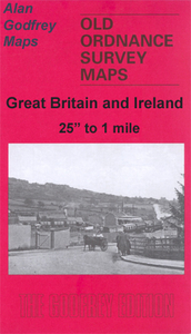
£7.99
Packed with facts & tantalising anecdotes from experts & bursting with colour photographs, learn all about space in this fresh take on the subject that kids with love. It`s time to learn everything about space! Each book in the National Geographic Kids Everything series has more than 100 pictures, an explorer`s corner with from-the-field anecdotes & tips, fun facts throughout, maps & infographics, an illustrated diagram, a photo gallery, cool comparisons, a behind-the-scenes photograph, an interactive glossary, & more. ...
Archived Product
£7.99
Packed with facts & tantalising anecdotes from experts & bursting with colour photographs, learn all about volcanoes & earthquakes in this fresh take on the subject that kids with love. It`s time to learn everything about volcanoes & earthquakes! Each book in the National Geographic Kids Everything series has more than 100 pictures, an explorer`s corner with from-the-field anecdotes & tips, fun facts throughout, maps & infographics, an illustrated diagram, a photo gallery, cool comparisons, a behind-the-scenes photograph, an interactive glossary, & more. ...
Archived Product
£7.99
Packed with facts & tantalising anecdotes from experts & bursting with colour photographs, learn all about weather in this fresh take on the subject that kids with love. It`s time to learn everything about weather! Each book in the National Geographic Kids Everything series has more than 100 pictures, an explorer`s corner with from-the-field anecdotes & tips, fun facts throughout, maps & infographics, an illustrated diagram, a photo gallery, cool comparisons, a behind-the-scenes photograph, an interactive glossary, & more. ...
Archived Product
£7.99
Boxing Day, Melbourne 2010: a packed house of over 80, 000 sits down to watch the crucial fourth Test unfold. Three days later, only 12, 000 remain
- & it`s just the Barmy Army, celebrating as England retain the Ashes. They run through their full repertoire of songs, cheering on England`s success. Meanwhile, the England players salute those who have made the effort to be there, spending thousands of pounds to support their side, inspiring them to another great victory. What was it like to be there? How did it come to pass that thousands gathered together? Who is the trumpeter? Who came up with the songs? What else do the Barmy Army get up to when the cricket finishes? This book answers all those questions, & many more, providing a brilliant & hilarious insight to life on tour with the Barmy Army. For those who were there, it will bring back a flood of memories. For those who weren`t, this book will show you what you missed, & why you need to join in next time to have the time of your life.
...
Archived Product
£3.50
Evesham & Bengeworth in 1903 in a fascinating series of reproductions of old Ordnance Survey plans in the Alan Godfrey Editions, ideal for anyone interested in the history of their neighbourhood or family. The map is double-sided, covering the central & southern part of Evesham & extending across the River Avon to include Great Hampton & Little Hampton. The main map covers the centre of the town from Central Market & Swan Lane southward. Features include All Saints church, St Lawrence`s church, Avondale Mills, Bengeworth Bridge, Merstow Green, Town Hall, Vine Street, Abbey Gardens, The Workman Gardens, Owlett`s End, Little Hampton, Great Hampton, Evesham Workhouse, Hampton Manor, Eastwick, Fairfield, Midland Railway with Bengeworth station, No Gains Farm, St Andrew`s church, etc. On the reverse is part of the adjacent map 49.04 extending coverage eastward to include more of Bengeworth with St Peter`s church, old church site, brick works, cemetery, etc. A list of private residents from an 1896 directory is also provided. About the Alan Godfrey Editions of the 25” OS Series: Selected towns in Great Britain & Ireland are covered by maps showing the extent of urban development in the last decades of the 19th & early 20th century. The plans have been taken from the Ordnance Survey mapping & reprinted at about 15 inches to one mile (1:4, 340). On the reverse most maps have historical notes & many also include extracts from contemporary directories. Most maps cover about one mile (1.6kms) north/south, one & a half miles (2.4kms) across; adjoining sheets can be combined to provide wider coverage.FOR MORE INFORMATION & A COMPLETE LIST OF ALL AVAILABLE TITLES PLEASE CLICK ON THE SERIES LINK. ...
Archived Product
£7.95
Northern Evia (Euboea) in a series from Anavasi covering selected popular areas of central mainland Greece & the Peloponnese with GPS compatible, detailed topographic road maps at 1:100, 000, printed on waterproof & tear-resistant paper. Contours at 100m intervals (or 50m where indicated in the individual descriptions), relief shading & spot heights present the topography, & the maps also show variations in vegetation: forest, shrubbery, orchards, & vineyards. Road network

Includes::
minor unsurfaced roads, indicating those in poor condition. Intermediate distances are marked on main & secondary routes. Archaeological or historical sites & other places of interest are highlighted, with symbols marking mountain refuges, caves, thermal spas, etc. Names of town, villages, & most geographical features & places of interest are in both Greek & Latin alphabet. The maps have both UTM grid lines & ticks plus crosshairs for latitude & longitude lines at 5

...
Archived Product
£8.50
Southern Evia (Euboea) with a part of eastern Attica t 1:100, 000 & 1:50, 000 in a series from Anavasi covering selected popular areas of central mainland Greece & the Peloponnese with GPS compatible, detailed topographic road maps printed on waterproof & tear-resistant paper. Contours at 100m intervals (or 50m where indicated in the individual descriptions), relief shading & spot heights present the topography, & the maps also show variations in vegetation: forest, shrubbery, orchards, & vineyards. Road network

Includes::
minor unsurfaced roads, indicating those in poor condition. Intermediate distances are marked on main & secondary routes. Archaeological or historical sites & other places of interest are highlighted, with symbols marking mountain refuges, caves, thermal spas, etc. Names of town, villages, & most geographical features & places of interest are in both Greek & Latin alphabet. The maps have both UTM grid lines & ticks plus crosshairs for latitude & longitude lines at 5

...
Archived Product
£8.99
Evia (Euboea) with Skyros at 1:110, 000 on a double-sided, contoured & GPS compatible, topographic road map from Anavasi printed on light, waterproof & tear-resistant synthetic paper. The map divides Evia north/south, with coverage on the southern half extending to the outskirts of Athens; the northern half extends west to Livadia. Contours at 100m intervals, enhanced by relief shading & altitude colouring, plus spot heights & plenty of names of peaks, mountain ranges, etc, provide & excellent picture of the region’s topography. Names of most towns & villages are in both Greek & Latin alphabets; names of geographical features & of places of interest highlighted on the map vary, with some shown only in Greek. Road network differentiates between asphalted & unsurfaced roads & indicates difficult roads. Driving distances are shows on main & selected local roads & locations of petrol stations are marked. Railway lines & ferry connections are included. Symbols highlight various places of interest including campsites & mountain refuges, archaeological sites, monasteries, beaches, harbours & marinas, etc. For GPS users UTM grid is drawn at 5-km intervals, with additional crosshairs for latitude & longitude at 1’ intervals. The index is in the detachable map cover.A special feature of this edition are bilingual descriptions of 12 best natural sites highlighted on the map. Map legend & the text include English. ...
Archived Product
£9.99
Evia (Euboea) with Skyros at 1:110, 000 on a double-sided, contoured & GPS compatible, topographic road map from Anavasi printed on light, waterproof & tear-resistant synthetic paper. The map divides Evia north/south, with coverage on the southern half extending to the outskirts of Athens; the northern half extends west to Livadia. Contours at 100m intervals, enhanced by relief shading & altitude colouring, plus spot heights & plenty of names of peaks, mountain ranges, etc, provide & excellent picture of the region’s topography. Names of most towns & villages are in both Greek & Latin alphabets; names of geographical features & of places of interest highlighted on the map vary, with some shown only in Greek. Road network differentiates between asphalted & unsurfaced roads & indicates difficult roads. Driving distances are shows on main & selected local roads & locations of petrol stations are marked. Railway lines & ferry connections are included. Symbols highlight various places of interest including campsites & mountain refuges, archaeological sites, monasteries, beaches, harbours & marinas, etc. For GPS users UTM grid is drawn at 5-km intervals, with additional crosshairs for latitude & longitude at 1’ intervals. The index is in the detachable map cover.A special feature of this edition are bilingual descriptions of 12 best natural sites highlighted on the map. Map legend & the text include English. ...
Archived Product
£12.99
Map No. 1263, Evian-les-Bains, in the topographic survey of Switzerland at 1:25, 000 from Bundesamt für Landestopographie (swisstopo), covering the whole country on 247 small format sheets, with special larger maps published for popular regions including some titles now available in hiking versions. Highly regarded for their superb use of graphic relief & hill shading, the maps give an almost 3-D picture of Switzerland`s mountainous terrain. Contours are at 10 m intervals, with 20m intervals in the mountainous areas. All the maps have a 1-km grid for Swiss national coordinates (datum CH 1903). * Small format sheets (Nos. 1011
- 1374)* Map legend in the language of the area covered by the map. Additional margin ticks show latitude & longitude in steps of 2`. The area covered by each map is 17 x 12 km (11 x 7 miles approx). * Special larger sheets (Nos. from 2501 onwards) – STANDARD editions:* No map legend is included but a separate leaflet can be provided instead. The area covered by each map is 25 x 17 km (15 x 11 miles approx).* Special larger sheets (Nos. from 2501 onwards) – HIKING editions:* An overprint highlights hiking, mountain & alpine paths, including regional & national long-distance trails. The maps also show bus routes with bus stops, plus inns in remote locations. The area covered by each map is 25 x 17 km (15 x 11 miles approx).
...
Archived Product

Evesham North 1903

Evesham North in 1903 in a fascinating series of reproductions of old Ordnance Survey plans in the Alan Godfrey Editions, ideal for anyone interested in the history of their neighbourhood or family. The map covers the northern part of Evesham, extending northward to Green Hill and Twyford House, westward to Rawlings Farm. Features include GWR and MR railways with both Evesham stations, engine shed, Smithfield Market, cottage hospital, saw mill, River Avon, many orchards and allotments used as orchards, Grammar School, Abbey Manor Farm, the site of Battle of Evesham (though probably not the precise site), Hampton Parks Farm, etc. On the reverse are the commercial entries from an 1896 directory. About the Alan Godfrey Editions of the 25” OS Series:Selected towns in Great
Britain and Ireland are covered by maps showing the extent of urban development in the last decades of the 19th and early 20th century. The plans have been taken from the Ordnance Survey mapping and reprinted at about 15 inches to one mile (1:4, 340). On the reverse most maps have historical notes and many also include extracts from contemporary directories. Most maps cover about one mile (1.6kms) north/south, one and a half miles (2.4kms) across; adjoining sheets can be combined to provide wider coverage.FOR MORE INFORMATION AND A COMPLETE LIST OF ALL AVAILABLE TITLES PLEASE CLICK ON THE SERIES LINK.
RIP - This product is no longer available on our network. It was last seen on 25.09.2019

This page now acts as a permanent archive for this product. Add more information using the comments box below to ensure it can still be found by future generations.

Use our search facility to see if it is available from an alternative contributor.
  • External links may include paid for promotion
  • Availability: Out Of Stock
  • Supplier: Stanfords
  • SKU: 9780850542875
Availability: In Stock
£3.50

Product Description

Evesham North in 1903 in a fascinating series of reproductions of old Ordnance Survey plans in the Alan Godfrey Editions, ideal for anyone interested in the history of their neighbourhood or family. The map covers the northern part of Evesham, extending northward to Green Hill & Twyford House, westward to Rawlings Farm. Features include GWR & MR railways with both Evesham stations, engine shed, Smithfield Market, cottage hospital, saw mill, River Avon, many orchards & allotments used as orchards, Grammar School, Abbey Manor Farm, the site of Battle of Evesham (though probably not the precise site), Hampton Parks Farm, etc. On the reverse are the commercial entries from an 1896 directory. About the Alan Godfrey Editions of the 25” OS Series: Selected towns in Great Britain & Ireland are covered by maps showing the extent of urban development in the last decades of the 19th & early 20th century. The plans have been taken from the Ordnance Survey mapping & reprinted at about 15 inches to one mile (1:4, 340). On the reverse most maps have historical notes & many also include extracts from contemporary directories. Most maps cover about one mile (1.6kms) north/south, one & a half miles (2.4kms) across; adjoining sheets can be combined to provide wider coverage.FOR MORE INFORMATION & A COMPLETE LIST OF ALL AVAILABLE TITLES PLEASE CLICK ON THE SERIES LINK.

Reviews/Comments

Add New

Price History

Vouchers

No voucher codes found.
Do you know a voucher code for this product or supplier? Add it to Insights for others to use.

Facebook

Jargon Buster

Contemporary - Modern era design
Engine - A machine designed to convert fuel into motion
Contemporary - A design reference to indicate post war modern design
History - Anything that happens in the past. An acedemic subject.
Railways - A set of tracks that have been laid for the purpose of trains to travel up and down them
Precise - A measurement on the accuracy of something
Contemporary - An object that is living in the same time.
Mill - A building which can grind grain into flour.
Cottage - A house typically found in the country, commonly small in size.
Ideal - Something that satisfies a perfect criteria.
Family - A group of people that live together made up from parents and children.

Supplier Information

Stanfords
Stanfords was established in 1853 and opened their iconic Covent Garden flagship store in 1901. They have become the top retailer of maps, travel books and accessories in the UK and arguably offer the largest selection of maps and travel books worldwide. Famous names such as Captain Robert Falcon Scott, Ranulph Fiennes and Michael Palin have purchased from Stanfords. They now have a shop in Bristol and both stores together with other venues operate a calendar of events including talks, book signings and exhibitions. As a specialist map retailer, the map selection is comprehensive and includes road maps, street maps and walking maps from worldwide destinations, as well as a selection of world atlases and wall maps. Books include travel guides and travel literature. Stanfords also stock globes, from miniatures made of blue marble to magnificent floor-standing globes. The website features a selection of interesting articles on travel topics.
Page Updated: 2023-11-12 20:15:36

Community Generated Product Tags

Oh No! The productWIKI community hasn't generated any tags for this product yet!
Menu