
 United Kingdom
 France
 Germany
 Netherlands
 Sweden
 USA
USA
 Italy
Italy
 Spain
Spain
More From Contributor


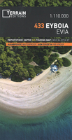
Evia / Euboea Terrain Editions
Evia (Euboea) with Skyros at 1:110, 000 on a double-sided, contoured and GPS compatible, topographic road map from Anavasi printed on light, waterproof and tear-resistant synthetic paper. The map divides Evia north/south, with coverage on the southern half extending to the outskirts of Athens; the northern half extends west to Livadia. Contours at 100m intervals, enhanced by relief shading and altitude colouring, plus spot heights and plenty of names of peaks, mountain ranges, etc, provide and excellent picture of the region’s topography. Names of most towns and villages are in both Greek and Latin alphabets; names of geographical features and of places of interest highlighted on the map vary, with some shown only in Greek. Road network differentiates between asphalted and
unsurfaced roads and indicates difficult roads. Driving distances are shows on main and selected local roads and locations of petrol stations are marked. Railway lines and ferry connections are included. Symbols highlight various places of interest including campsites and mountain refuges, archaeological sites, monasteries, beaches, harbours and marinas, etc. For GPS users UTM grid is drawn at 5-km intervals, with additional crosshairs for latitude and longitude at 1’ intervals. The index is in the detachable map cover.A special feature of this edition are bilingual descriptions of 12 best natural sites highlighted on the map. Map legend and the text include English.
unsurfaced roads and indicates difficult roads. Driving distances are shows on main and selected local roads and locations of petrol stations are marked. Railway lines and ferry connections are included. Symbols highlight various places of interest including campsites and mountain refuges, archaeological sites, monasteries, beaches, harbours and marinas, etc. For GPS users UTM grid is drawn at 5-km intervals, with additional crosshairs for latitude and longitude at 1’ intervals. The index is in the detachable map cover.A special feature of this edition are bilingual descriptions of 12 best natural sites highlighted on the map. Map legend and the text include English.

Product Description
Reviews/Comments
Add New
Vouchers
No voucher codes found.
Do you know a voucher code for this product or supplier? Add it to Insights for others to use.
Do you know a voucher code for this product or supplier? Add it to Insights for others to use.
 Denmark