
 United Kingdom
 France
 Germany
 Netherlands
 Sweden
 USA
USA
 Italy
Italy
 Spain
Spain
More From Contributor


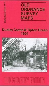
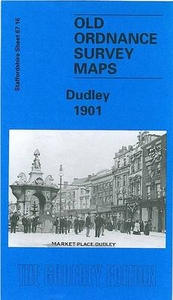
Dudley Castle 1901
Dudley Castle in 1901 in a fascinating series of reproductions of old Ordnance Survey plans in the Alan Godfrey Editions, ideal for anyone interested in the history of their neighbourhood or family. The map covers the northern part of Dudley, Tipton Green, Burnt Tree and much of Dudley Port. Features include Dudley Castle, GWR railway with Dudley station, LNWR South Staffordshire Line with Sedgley Junction, The Priory, Dudley Canal with tunnel, Birmingham Canal (Wolverhampton Level), tramways and depot, Guest Hospital, Victoria Park, Todd`s End, Lime Works, Coneygree Colliery, old coal shafts, Burnt Tree area, St Michael`s church, Model Sausage Factory, Park Hotel, industrial tramways, etc. The map doubles as Worcestershire sheet 1.12 and highlights the complicated
county structure in this area, with two detached portions of Worcestershire.About the Alan Godfrey Editions of the 25” OS Series:Selected towns in Great Britain and Ireland are covered by maps showing the extent of urban development in the last decades of the 19th and early 20th century. The plans have been taken from the Ordnance Survey mapping and reprinted at about 15 inches to one mile (1:4, 340). On the reverse most maps have historical notes and many also include extracts from contemporary directories. Most maps cover about one mile (1.6kms) north/south, one and a half miles (2.4kms) across; adjoining sheets can be combined to provide wider coverage.FOR MORE INFORMATION AND A COMPLETE LIST OF ALL AVAILABLE TITLES PLEASE CLICK ON THE SERIES LINK.
county structure in this area, with two detached portions of Worcestershire.About the Alan Godfrey Editions of the 25” OS Series:Selected towns in Great Britain and Ireland are covered by maps showing the extent of urban development in the last decades of the 19th and early 20th century. The plans have been taken from the Ordnance Survey mapping and reprinted at about 15 inches to one mile (1:4, 340). On the reverse most maps have historical notes and many also include extracts from contemporary directories. Most maps cover about one mile (1.6kms) north/south, one and a half miles (2.4kms) across; adjoining sheets can be combined to provide wider coverage.FOR MORE INFORMATION AND A COMPLETE LIST OF ALL AVAILABLE TITLES PLEASE CLICK ON THE SERIES LINK.

Product Description
Reviews/Comments
Add New
Intelligent Comparison
Archived Product
Dudley West 1901 Stanfords
£3.50
Archived Product

Dundee East 1901 Stanfords
£3.50
Archived Product
Dudley 1901 Stanfords
£3.50
Archived Product
Dundee West 1901 Stanfords
£3.50
Vouchers
No voucher codes found.
Do you know a voucher code for this product or supplier? Add it to Insights for others to use.
Do you know a voucher code for this product or supplier? Add it to Insights for others to use.
 Denmark