
 United Kingdom
 France
 Germany
 Netherlands
 Sweden
 USA
USA
 Italy
Italy
 Spain
Spain
More From Contributor


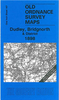


Dudley West 1881 (Colour Edition)
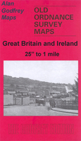
Dudley West in 1881 in a fascinating series of reproductions of old Ordnance Survey plans in the Alan Godfrey Editions, ideal for anyone interested in the history of their neighbourhood or family. Two versions have been published for this area. The maps cover the western part of Dudley town, including the Old Dock area, and extend westward to the Old Park area, and southward to Scotts Green and Blowers Green. Other districts mentioned include Thornleigh Collieries, Springs Mire, New Dock, Sunnyside. The area is split between Staffordshire and Worcestershire, and doubles as Worcestershire sheet 1.15. Features include tramways, short stretch of GWR OWW line, several mineral railways, Yorkspark Colliery (disused), Thornleigh Works, old mine shafts, public baths, St Luke`s
church, schools, Russell`s Hall, Himley Colliery, Graveyard Farm, Parkhead Colliery (disused), St Augustine`s church, expanses of old industrial sites and coalfield, etc. The 1881 version is in colour, taken from the beautiful hand-coloured OS 1st Edition map.About the Alan Godfrey Editions of the 25” OS SeriesSelected towns in Great Britain and Ireland are covered by maps showing the extent of urban development in the last decades of the 19th and early 20th century. The plans have been taken from the Ordnance Survey mapping and reprinted at about 15 inches to one mile (1:4, 340). On the reverse most maps have historical notes and many also include extracts from contemporary directories. Most maps cover about one mile (1.6kms) north/south, one and a half miles (2.4kms) across;
adjoining sheets can be combined to provide wider coverage.FOR MORE INFORMATION AND A COMPLETE LIST OF ALL AVAILABLE TITLES PLEASE CLICK ON THE SERIES LINK.
 "Pin It")
Product Description
Reviews/Comments
Add New
Vouchers
No voucher codes found.
Do you know a voucher code for this product or supplier? Add it to Insights for others to use.
Do you know a voucher code for this product or supplier? Add it to Insights for others to use.
 Denmark