
 United Kingdom
 France
 Germany
 Netherlands
 Sweden
 USA
USA
 Italy
Italy
 Spain
Spain
More From Contributor


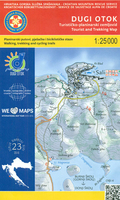
Dugi, Iž & Sestrunj Islands Croatian Mountain Rescue Service 25K Map
Dugi Otok - the “Long Island”, with the nearby Iž, Sestrunj, Rava, Zverinac and the surrounding smaller islands on a contoured and GPS compatible, double-sided map at 1:25, 000 from the Croatian Mountain Rescue Service. Contours at 10m intervals enhanced by relief shading provide excellent presentation of the terrain, with markings for various topographic features. Waymarked hiking paths are highlighted and the map also indicates which local roads and tracks are suitable for cycling. Symbols mark various facilities and places of interest, including different types of tourist accommodations (hotels, apartments, campsites), restaurants, petrol stations, etc. The map has a 1km UTM grid, plus latitude and longitude lines at 1’ intervals. Map legend and the accompanying
notes about the islands include English.This map is printed on demand, and if it`s out of stock it could take 3 - 4 months waiting time.To see the list of titles in this series please click on the series link.
notes about the islands include English.This map is printed on demand, and if it`s out of stock it could take 3 - 4 months waiting time.To see the list of titles in this series please click on the series link.

Product Description
Reviews/Comments
Add New
Vouchers
No voucher codes found.
Do you know a voucher code for this product or supplier? Add it to Insights for others to use.
Do you know a voucher code for this product or supplier? Add it to Insights for others to use.
 Denmark