More From Contributor

£5.99
Tourist street plan of Zurich in Hallwag’s City Flash series: laminated, waterproof & tear-resistant, presented in a handy concertina format, with street plans, maps of the main shopping street, the airport & the city’s environs, plus a transport network diagram. The main plan, divided between the two sides of the map, covers the city with its suburbs at 1:16, 000, extending from Oerlikon in the north to Tiefenbrunnen on Lake Zurich & from Altstetten in the west to Hottingen in the east. The city centre is shown enlarged to 1:9, 000. Both plan show tram & bus routes with stops & line numbers, car parks & various places of interest. The enlargement also indicates one way streets & taxi ranks. The index lists only a selection of streets, but the map

Includes::
lists of the city’s museums & other places of interest. Zurich’s main shopping street, Bahnhof Strasse leading from the central railway station to the lake, is shown with colour coded names of restaurants & cafes, banks, various shops including clothing & watches, etc. Also included are: a detailed plan of the airport showing access & parking facilities, a map of the city’s outer suburbs showing road connections to the airport, a diagram of the city’s entire public transport network, plus general tourist information on emergency phone numbers, etc.* Hallwag City Flash street plans* are produced in a handy concertina format & are waterproof & tear-resistant. The maps are double-sided & combine a street plan of the city’s central district with an enlargement for the main shopping/entertainment area, a road map of the environs, a diagrams of the metro and/or other public transport lines, a plan of the airport, lists of main places of interest, plus emergency numbers & other useful tourist information.

...
Archived Product
£6.99
This is a savvy city breakers' pocket guide to seeing & doing more in beautiful Zurich
- the world's top ranking city for standard
...
Archived Product
£10.00
Zurich Crumpled City Map from a collection of street plans of major cities printed on soft, very lightweight (approximately only 20g) & yet extremely tear-resistant & 100% waterproof material, specifically designed to be scrunched & crammed into pockets, handbags & backpacks, either on its own or in the pouch from the same material provided with each map. Creases are a fully intentional part of the quirkiness of the Crumpled City maps – the more battered they are they better they look. Parks & other green spaces are highlighted, as are metro stations, & important buildings are named. Each map also highlights 10 recommended “soulsights”, imaginatively chosen to present the essence of each city rather than the most obvious tourist destinations. The accompanying index placed next to the map lists locations of tourist interest: selected streets & squares, monuments & historical places, museums & galleries, parks, etc. Whilst cartographically these Crumpled City maps provide perhaps not the most precise representation of the street network, they are handy for sightseeing, light & durable, can be used as a table cloth when picnicking in the Luxembourg Gardens, Hyde Park, the Retiro or the Central Park, or just as an unusual decoration… Selected cities are also presented on more colourful ‘junior’ maps, specially designed for children. Drawings highlight not only important buildings & famous locations but also places which will specifically appeal to children: toy shops, bookshops, best ice cream, etc. Each title has a list of the recommended not-to-be missed locations with addresses &, where available, websites. To see the full list of cities covered by this unique series please click on the series link. ...
Archived Product
£4.99
Central Zurich in a series of handy pocket street plans from Freytag & Berndt. Each map is laminated, so waterproof & tear-resistant, & highlights the publishers’ recommendations of five best choices in five categories: shopping, restaurants & cafes, culture, nightlife & sights. On one side is an indexed street plan annotated with colour-coded markers highlighting the publishers’ recommendations, all listed on the reverse of the map with brief notes in several languages. In larger cities the plans cover only the central districts. Also provided are a small road map of the city’s environs, if appropriate a diagram of the metro network, & a Fact Box with phone numbers for tourist offices, car hire & emergency services. Map legend & notes on the recommendations include English. To see other titles in this series please click on the series link. ...
Archived Product
£8.99
The double-sided city maps include all essential information:- detailed & clear representation of town centre- appealing 3D-display of selected typical buildings- brief description of 16 highlights in 4 languages complemented with attractive pictures- useful additional information for a successful trip (vicinity map, public transport, travel information, climate chart, index of important streets)- up-to-date amendments via QR-Code (airports, local traffic, fairgrounds…). ...
Archived Product
£19.99
Zurich area at 1:60, 000 in Kümmerly + Frey’s hiking series of Switzerl&, with most titles now printed on light, waterproof & tear-resistant plastic paper. The series offers a popular alternative to Swiss survey maps & cartography which many walkers find easier to follow. Coverage of the whole country is designed so that each title presents a popular hiking area. The maps have contours at 50 or 25-metre intervals according to the terrain, enhanced by graphic relief & shading. An overprint distinguishes between sign-posted hiking paths, mountain path where proper walking shoes are necessary, & alpine paths requiring special equipment. Most titles now also indicate national & regional long-distance hiking routes, each annotated with its official number. Mountain huts are marked, plus various types of accommodation: campsites, youth hostels, “ Friends of Nature” houses, & secluded hotels & restaurants. Road network indicates local bus routes with stops. Railways, narrow gauge mountain railways, cable car lines, & chair lifts are shown, with various symbols highlighting places of interest, viewpoints, picnic sites, swimming pools, etc. Each title covers an area of Approx. 60 x 42 km (37 x 26 miles). The maps have a 1km Swiss national grid, plus latitude & longitude margin ticks at 5’ intervals. * Map legend

Includes::
English.* On the reverse, an index of towns & villages

Includes::
names of geographical features such as mountains, alpine passes, glaciers, lakes, rivers, as well as places of interest. Also provided is an overview road map of surrounding region.


...
Archived Product
£18.99
33 specially selected hiking trails in the Züricher Oberl&, the mountains east of Zurich between Winterthur & the eastern part Lake Zurich, presented at 1:50, 000 on a waterproof & tear-resistant, contoured & GPS compatible map from the Hallwag/Kümmerly + Frey group, with route profiles, grading for the severity of the terrain & the degree of fitness required, etc. The cartography provides an excellent picture of the terrain through contours at 25-metre intervals enhanced by shading, graphic relief for exposed rock, & colouring for glaciers & woodlands. All local footpaths are on the maps, but the overprint specifically highlights 33 trails selected by the publishers in collaboration with Geo-tracks. The colouring of each trail indicates the degree of fitness needed, from “no physical shape required” to “extremely high level of physical fitness necessary”. The trails start near a railway station or a bus stop (the colouring of the road network indicates routes with public transport & locations of individual bus stops). The maps have the lines of the Swiss national grid at 1-km intervals. On the reverse each trail has a route profile, its grading according to severity of the terrain & the degree of fitness required to attempt it, details of length & approximate timing, the change in altitude on assent & descent, plus a brief description. Map legend

Includes::
English; all the text on the reverse is in German. Each title also

Includes::
a code for a free download onto a smartphone. To see other titles in this series please click on the series link.USEFUL TIP: the same cartography, reduced slightly to 1:60, 000, is used in Kümmerly + Frey’s hiking series with highlighting for all the waymarked trails rather than, as in this series, just a selection of 33 special routes recommended by the publishers.


...
Archived Product
£12.99
Zurich Then & Now map from Swisstopo, Switzerland’s national survey organization, with an excellent combination of two detailed topographic maps & two aerial photos, comparing presentation of the city at different stages in its development. One side shows the city & its environs on two topographic maps at 1:25, 000: a beautiful colour reproduction of Swiss Survey’s famous “ Dufourkarte” series drawn between 1846 & 1851, contrasting it with a map of the same area from 2007. On the reverse there are two aerial images at 1:16, 000: a black & white photo from 1931 with the same area photographed in colour in 2007. The accompanying text about the two topographic series & the two aerial imagery series is in French & German only. For the list of other titles in this series please click on the series link. ...
Archived Product
£10.99
Zurich on a beautifully h&-drawn panorama map from Gecko Maps offering a 3-D bird`s-eye view of the city, with on the reverse a more detailed enlargement of its historic centre. Every building is drawn to scale with full architectural details. Drawn by the renowned artist Ruben Atoyan who specializes in this kind of mapping, this title presents on one side a view of the city looking south-east, with the mountains across Lake Zurich framing the top of the map. Coverage to the west extends to the Sihl & a panel at the bottom presents a selection of the city’s best know buildings, including the central railway station, the town hall, university buildings & several churches. On the reverse the city’s historic centre is presented in greater detail, highlighting recommended sightseeing routes to view its most interesting buildings. Map legend

Includes::
English.

...
Archived Product
£8.99
Pocket street plan of Zurich at 1:17, 500 from Orell Füssli’s range of street plans of Swiss cities, providing coverage of the central section across the city & its suburbs, from Wollishofen on Lake Zurich across to the international airport at Kloten, but with only limited coverage of the western & eastern districts. Tram & bus routes are shown with line numbers & stops, & on an enlargement for the city centre at 1:10, 000 one way streets are also marked. On some longer streets selected house numbers are indicated. The map is indexed &

Includes::
brief notes & a list of useful phone numbers. Map legend & the text include English. Unfortunately some of the street names are difficult to read, particularly on the enlargement for the city centre, almost obliterated by symbols highlighting various places of interest. Better know for its gnomes & bankers, Zurich is apparently full of night clubs!

...
Archived Product

Zurich In 3-D Wall Map

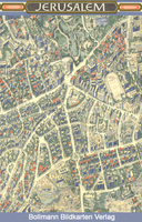
One of a series of beautiful, hand-drawn plans, offering bird's-eye views of popular cities. Every building is drawn to scale with full architectural details, from street arcades to rooftops and inner courtyards. The plans were drawn in 1950s to 1970s and offer a unique opportunity to see these cities as they were before many of the often controversial redevelopments.
RIP - This product is no longer available on our network. It was last seen on 25.09.2019

This page now acts as a permanent archive for this product. Add more information using the comments box below to ensure it can still be found by future generations.

Use our search facility to see if it is available from an alternative contributor.
  • Availability: Out Of Stock
  • Supplier: Stanfords
  • SKU: XL00000030649
Availability: In Stock
£16.95

Product Description

One of a series of beautiful, h&-drawn plans, offering bird's-eye views of popular cities. Every building is drawn to scale with full architectural details, from street arcades to rooftops & inner courtyards. The plans were drawn in 1950s to 1970s & offer a unique opportunity to see these cities as they were before many of the often controversial redevelopments.

Reviews/Comments

Add New

Price History

Vouchers

No voucher codes found.
Do you know a voucher code for this product or supplier? Add it to Insights for others to use.

Facebook

Jargon Buster

Eye - An organ which detects light
Hand - A part of the body at the end of the arm
Hand - A pointer which indicates time on a clock face
Wall - A physical barrier between two areas
Popular - Something that is admired and liked by many people.

Supplier Information

Stanfords
Stanfords was established in 1853 and opened their iconic Covent Garden flagship store in 1901. They have become the top retailer of maps, travel books and accessories in the UK and arguably offer the largest selection of maps and travel books worldwide. Famous names such as Captain Robert Falcon Scott, Ranulph Fiennes and Michael Palin have purchased from Stanfords. They now have a shop in Bristol and both stores together with other venues operate a calendar of events including talks, book signings and exhibitions. As a specialist map retailer, the map selection is comprehensive and includes road maps, street maps and walking maps from worldwide destinations, as well as a selection of world atlases and wall maps. Books include travel guides and travel literature. Stanfords also stock globes, from miniatures made of blue marble to magnificent floor-standing globes. The website features a selection of interesting articles on travel topics.
Page Updated: 2023-11-12 20:15:36

Community Generated Product Tags

Oh No! The productWIKI community hasn't generated any tags for this product yet!
Menu