
 United Kingdom
 France
 Germany
 Netherlands
 Sweden
 USA
USA
 Italy
Italy
 Spain
Spain
More From Contributor


Amsterdam In 3-D Wall Map
Amsterdam on a beautiful and decorative panorama plan from Bollmann-Bildkarten-Verlag, publishers of 3-D street plans of numerous German cities and selected other locations, presenting the city as it was before its most controversial re-development, the Stopera.Every building is drawn to scale with full architectural details, from rooftop gables to hidden inner courtyards. The plan was drawn before the controversial re-development of the Waterlooplein area to build new city hall and the opera house. So no Stopera - just the old houses facing the Amstel!
Product Description
Reviews/Comments
Add New
Intelligent Comparison
Archived Product
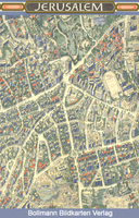
Jerusalem In 3-D Wall Map Stanfords
£27.99
Archived Product
Lucerne In 3-D Wall Map Stanfords
£19.99
Archived Product
Zurich In 3-D Wall Map Stanfords
£16.95
Archived Product
Copenhagen In 3-D Wall Map Stanfords
£19.99
Vouchers
No voucher codes found.
Do you know a voucher code for this product or supplier? Add it to Insights for others to use.
Do you know a voucher code for this product or supplier? Add it to Insights for others to use.
 Denmark