
 United Kingdom
 France
 Germany
 Netherlands
 Sweden
 USA
USA
 Italy
Italy
 Spain
Spain
More From Contributor


Amsterdam Flexi Map
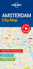
Central Amsterdam on an Insight Flexi Map in their new format introduced to provide more convenient access to the special features of this series: various additional maps and/or street plans plus tourist information including a list of must-see sights. The map is tear-resistant, waterproof, and can be written on with non-permanent marker pens.On one side is an indexed street plan at 1:12, 000 showing the canal ring and the surrounding districts. Coverage extends from the A10 motorway and the Rembrandt Park in the west to eastern docks; and from Vondelpark and The Pijp across the Ij to include parts of North Amsterdam. On the reverse are this title’s additional features: - An enlargement showing in greater detail the city’s historic heart, from the Singel – the first concentric
canal to the tunnel under the Ij; also indexed for streets, points of interest, etc.- A map of Amsterdam’s tram network plus a diagram of the metro lines.- An indexed road map at 1:360, 000 of the environs of Amsterdam including Schiphol Airport, Haarlem, Leiden and Utrecht.- Brief descriptions of the city’s 28 main sights, neatly grouped into sections covering Top Museums and Galleries, Other Major Attractions, Main Shopping Areas and Markets, plus Further Afield - all prominently highlighted on the street plans and/or the road map of the environs.- Information about Getting Around and Facts for Visitors, including tourist offices, public holidays, opening times, money, tipping, health, telecommunications and monthly climate charts.To see the list of other Insight Flexi
titles in this series please click on the series link.

Product Description
Reviews/Comments
Add New
Vouchers
No voucher codes found.
Do you know a voucher code for this product or supplier? Add it to Insights for others to use.
Do you know a voucher code for this product or supplier? Add it to Insights for others to use.
 Denmark